|
September 2001 Ohio Weather Observer Network Weather summaries, Station Data and Network News E-Mail: lrhuff@megsinet.net www.ohioweather.net |
|
October 1st ... OWON Transfer to Kent State University
October 1, 2001 was the transfer date for the Ohio Weather Observer Network to Dr. Scott Sheridan and Kent State University . Click on to http://sheridan.geog.kent.edu/owon/. , the new web site for the OWON. There you will find the various links of information that have been available on the original web site. You will note the form that allows each OWON observer to submit data electronically. Other options are: fax (330-672-4304) and mail (Dr. Scott Sheridan, Kent State University, P.O. Box 5190, Kent, OH 44242-0001). I want to take this final opportunity to thank each OWON observer for your committment in making daily weather observations that became the basis for the Ohio Weather Journal and ohioweather.net. I will miss the monthly contact that I have had with each observer via the monthly data but I am excited with the new possibilities as Scott and Tom take over at the helm of the OWON. The original OWON web site (ohioweather.net) has been discontinued but I will continue to post a link for the network. |
 New OWON Logo New OWON Logo |

|
Dr. Scott Sheridan & Dr. Tom Schmidlin Kent State University
|
|
Weather Station Summaries
|
| Springfield 2N #1 (Clark County) Dick Groeber - Both temperature and rainfall were above the station 30 year averages. Temperatures remained mild to warm during most of the month locally with high temperatures in the 70s and 80s until the final week when a cold air mass dropped high temperatures into the 50s. Low temperatures were in the 50s and 60s during the first two thirds. They dropped mostly into the 40s during the final third. The heaviest rainfall came between the 7th and 10th with 1.89 inches from rain showers and thundestorms. Lighter amounts fell sporadically throughout the remainder of the month.
Perrysville 4W #79 (Richland County) Katie Gerwig - Temperatures averaged 3 degrees cooler than normal. Precipitation was approximately 1 inch less than normal, although rain fell on 10 days with thunderstorms on 5 days. Ellet 1NW #118 (Summit County) Doug Miller - September is a transition month where at the beginning we can still get hot summer days and at the end of the month our nightly temps are dropping. I had my first readings of 30's coming as a wind chill first, then on the last day a 39.9 reading. I had a swing of 46.4 degrees this month from 86.3 to 39.9. I had a lot of days where my humidity maxed at 100%. This is unusual for me. September seemed wetter than usual(or at least damp).Fall will be on us soon. I usually clean my Stevenson Screen this month. Make any repairs I need to. I usually put an extra screen over my Davis water tipper so leaves don't clog it up. Wooster 7N #16 (Wayne County) Jack Sisler - Other than the storm that came through here on the 7th with strong winds and brief heavy rains, the weather was kind of bland. Temperatures were about 2 degrees below normal for the month; some of that attributed to the cool temperatures during the last week with temperatures almost 15 to 20 degrees below normal and wind chills in the 20s. Precipitation was almost 0.50 inch below normal even with having measurable precipitation on 14 days. This makes seven out of the last nine months with below normal precipitation and almost eight inches below normal for the year thus far. Cincinnati 5NW #13 (Hamilton County) Ronald E. Rothhaas Jr. - September was a rather tranquil month with a hint of early fall coming in a little ahead of schedule. While it started out hot and humid September averaged 2.1 degrees below normal with rainfall just 0.18 inches below normal. Kent 2W #53 (Portage County) Eric Wertz - September 2001 was a rather tranquil month weatherwise with average temperatures and average precipitation. Warm temperatures of at least 85 degrees occurred on the 7th, 8th and 9th with the first light frost of the season noted on the 30th with 36 degrees. Measurable precipitation was noted on 11 days. The heaviest rainfall was observed on the 21st with 0.68 inch in conjunction with a thunderstorm. A severe thunderstorm warning was issued on the 21st as some locales experienced rough weather. Fog was noted on the 22nd. Due to the lack of thunderstorm activity and weak fronts in September, the highest wind gust was only 23 mph on the 26th.
|
|
Seventh Annual Holiday Dinner
Northeast Ohio Chapter of the American Meteorological Society Friday, December 7, 2001 Final Score Restaurant 9062 State Route 14, Streetsboro, Ohio Located one-quarter mile east of the intersection of Route 43 and Route 14. The restaurant is on the left hand side of Route 14 as you head east. It is directly across the street from Kmart. The Final Score Restaurant has tan siding. This is an informal dinner where individuals pay for their own meal. There will be NO guest speaker. Bring your family and other weather enthusiasts. All Ohio Weather Observer Network participants are welcome. |
|
Directions from Cleveland and the Lakeshore Region
Take I-480 east, past I-77 and I-271 and into Portage County. Continue east on I-480 until it turns into Route 14. Take Route 14 east another two miles and you'll be in Streetsboro. Watch for the Final Score Restaurant on the left hand side, just 1/4 mile east of the Route 43 and Route 14 intersection on Route 14. |
|
Directions from Akron-Canton and points to the southwest
Take I-76 east through Akron and continue east to the Route 43 exit in Kent (Exit #33). Take Route 43 north through Kent and to Streetsboro. You will be on Route 43 for 10 miles before reaching Route 14 in Streetsboro. When you come to the intersection of Route 43 and Route 14 in Streetsboro, turn right onto Route 14 and head east for 1/4 mile. Watch for the Final Score Restaurant on the left hand side. |
|
September 2001 weather extremes
|
|
-
|
READING
|
DATE
|
STATION (s)
|
|
Highest Temperature
|
92
|
7th
|
Toledo NWS (Lucas County)
|
|
Lowest Temperature
|
33
|
30th
|
Aurora 3S (Portage County
|
|
Highest Precipitation
|
4.48
|
-
|
Perry 3SE (Lake County)
|
|
Lowest Precipitation
|
1.28
|
-
|
Sabina (Fayette/Clinton)
|
|
Highest Snowfall
|
-
|
-
|
-
|
|
Highest Wind Gust
|
47
|
7th & 8th
|
Toledo NWS (Lucas County) & Wooster 7N (Wayne County)
|
|
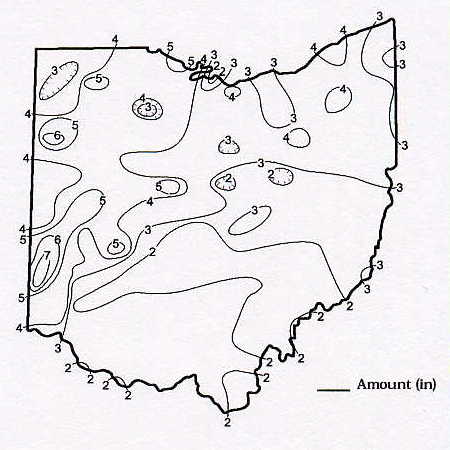
September 2001 Precipitation Maps
Courtesy of the Ohio Department of Natural Resources David H. Cashell Scott Kirk |
|
September 2001 Ohio Weather Data
|
|
Station
|
Max / Min Temperature
|
Mean Temp
|
Precipitation and Max 24 hr precipitation
|
Snowfall and Maximum 24 hr snow
|
High WindGust and Average High Wind Gust
|
High & Low Barometer
|
|
Akron-Canton NWS
|
86 (9) / 40 (30)
|
61.5
|
2.52 / 0.56 (24)
|
0
|
32 (13)
|
30.34 (14) / 29.82 (19)
|
|
Alliance 7S #21
|
-
|
-
|
-
|
0
|
-
|
-
|
|
Aurora 3S #3
|
89 (7) / 33 (30)
|
60.5
|
3.40 / 0.49 (13)
|
0
|
-
|
-
|
|
-
|
-
|
-
|
-
|
-
|
-
|
|
|
Brunswick 2NE #116
|
-
|
-
|
3.40 / 0.65 (25)
|
-
|
-
|
-
|
|
89 (7) / 38 (28)
|
64.5
|
3.50 / 0.92 (10)
|
0
|
24 (7) / 14.6
|
30.36 (29) / 29.80 (18)
|
|
|
Chillicothe 3S #40
|
89 (8) / 39 (29)
|
63.1
|
2.50 / 0.90 (20)
|
0
|
-
|
-
|
|
Cincinnati 5NW #13
|
87 (7) / 41 (25,28)
|
65.2
|
2.70 / 0.92 (24)
|
0
|
33 (8,9)
|
30.31 (29) / 29.78 (19)
|
|
Cincinnati NWS
|
86 (7) / 40 (25)
|
-
|
-
|
0
|
-
|
-
|
|
Cleveland NWS
|
87 (9) / 39 (30)
|
61.4
|
3.90 / 0.94 (24)
|
0
|
37 (21)
|
30.38 (14) / 29.79 (19)
|
|
Cleves 2NW
|
90 (4) / 40 (28)
|
-
|
-
|
-
|
26 (x) / 15.3
|
30.35 (x) / 29.78 (x)
|
|
Columbus 5NW #9
|
88 (7) / 40 (30)
|
63.5
|
1.41 / 0.33 (19)
|
0
|
19 (27)
|
-
|
|
Columbus NWS
|
88 (7) / 42 (30)
|
64.4
|
1.60 / 0.33 (18)
|
0
|
30 (13)
|
30.32 (14) / 29.78 (19)
|
|
Dayton NWS
|
85 (8) / 41 (30)
|
62.9
|
3.88 / 2.26 (10)
|
0
|
37 (9)
|
30.38 (29) / 29.76 (19)
|
|
Ellet 1NW #118
|
86 (9) / 40 (30)
|
-
|
1.99 / 0.44 (21)
|
0
|
-
|
30.39 (14) / 29.92 (19)
|
|
-
|
-
|
-
|
0
|
-
|
-
|
|
|
Kent 2W #53
|
86 (7,9) / 36 (30)
|
59.9
|
3.17 / 0.68 (21)
|
0
|
23 (26) / 15.7
|
30.35 (14) / 29.86 (19,20)
|
|
Kidron 1N #2
|
-
|
-
|
-
|
0
|
-
|
-
|
|
Lagrange 2SW #87
|
90 (9) / 36 (30)
|
62.5
|
2.83 / 0.66 (24)
|
0
|
25 (21) / 18.1
|
30.35 (14) / 29.79 (19)
|
|
Lancaster 4N #17
|
89 (x) / 42 (x)
|
-
|
1.46 / 0.37 (x)
|
0
|
23 (14) / -
|
-
|
|
Lodi 2S #23
|
91 (7) / 36 (30)
|
61.7
|
2.65 / 1.01 (21)
|
0
|
-
|
30.32 (15) / 29.80 (19)
|
|
Mansfield NWS
|
84 (9) / 41 (30)
|
60.7
|
2.46 / 0.67 (22)
|
0
|
32 (7)
|
30.35 (14) / 29.78 (19)
|
|
87 (7,9) / 38 (15,30)
|
60.6
|
4.16 / 0.88 (1)
|
0
|
31 (10) / 16.6
|
30.31 (14,15) / 29.85 (19)
|
|
|
Newcomerstown 1S #106
|
88 (7) / 36 (30)
|
61.8
|
1.64 / 0.57 (19)
|
0
|
29 (26) / 15.3
|
-
|
|
New Philadelphia 1NW #58
|
-
|
-
|
-
|
0
|
-
|
-
|
|
North Ridgeville 1N #32
|
-
|
-
|
-
|
-
|
-
|
-
|
|
Ottawa 4E #15
|
88 (7) / 40 (30)
|
61.1
|
3.53 / 1.15 (19)
|
0
|
35 (7) / 20.1
|
30.23 (14) / 29.51 (20)
|
|
Perry 3SE #38
|
85 (8) / 37 (30)
|
59.9
|
4.48 / 1.31 (25)
|
0
|
-
|
-
|
|
Perrysville 4W #79
|
85 (9) / 40 (15,16,18)
|
59.9
|
1.69 / 0.45 (19)
|
0
|
25 (26) / 10.5
|
-
|
|
Port Clinton 3W #14
|
-
|
-
|
-
|
0
|
-
|
-
|
|
86 (9) / 44 (26)
|
-
|
3.17 / 0.45 (22)
|
0
|
23 (25) / 13.9
|
30.38 (14) / 29.88 (19)
|
|
|
Rockbridge 4W #33
|
87 (7,8) / 42 (25,26)
|
62.9
|
1.46 / 0.69 (19)
|
0
|
-
|
-
|
|
Rocky River 1W #51
|
-
|
-
|
4.11 / 1.04 (24)
|
-
|
-
|
-
|
|
Sabina #113
|
-
|
-
|
1.28 / 0.35 (19)
|
0
|
-
|
-
|
|
Sandusky 1N #4
|
88 (7,9) / 42 (26)
|
63.2
|
4.45 / 0.86 (9)
|
0
|
32 (24) / 19.5
|
30.38 (14) / 29.76 (19)
|
|
Sharonville 2NE #43
|
-
|
-
|
-
|
-
|
-
|
-
|
|
Springfield 2N #1
|
88 (8,13) / 41 (28,30)
|
65.3
|
2.85 / 1.52 (9)
|
0
|
23 (24) / 12.0
|
30.36 (30) / 29.81 (19)
|
|
Spring Valley 2E #62
|
-
|
-
|
-
|
-
|
-
|
-
|
|
Stow 1SE #105
|
89 (7) / 43 (30)
|
62.4
|
3.34 / 0.56 (22)
|
0
|
-
|
30.39 (11) / 29.94 (19)
|
|
-
|
-
|
-
|
-
|
-
|
-
|
|
|
Sugarcreek 2SW #112
|
88 (7,9) / 38 (30)
|
61.7
|
1.31 / 0.40 (14)
|
0
|
24 (21) / 15.4
|
30.30 (29) / 29.87 (19)
|
|
Tiltonsville #117
|
89 (7) / 42 (30)
|
64.0
|
1.58 / 0.51 (24)
|
0
|
30 (26) / -
|
30.33 (14) / 29.85 (24)
|
|
Toledo 5NE #66
|
-
|
-
|
-
|
-
|
-
|
-
|
|
Toledo NWS
|
92 (7) / 43 (25)
|
63.1
|
4.72
|
0
|
47 (8)
|
30.40 (14) / 29.66 (19)
|
|
Van Wert #86
|
-
|
-
|
-
|
-
|
-
|
-
|
|
86 (7) / 37 (15)
|
61.0
|
2.74 / 0.47 (14)
|
0
|
47 (7) / 17.6
|
30.45 (15) / 29.90 (24)
|
|
|
Youngstown NWS
|
87 (7) / 39 (30)
|
60.4
|
2.61 / 0.76 (13)
|
0
|
33 (10)
|
30.34 (14) / 29.83 (24)
|
|
Zanesville 6N #48
|
87 (7) / 42 (26)
|
61.7
|
1.90 / 0.81 (19)
|
0
|
15 (24)
|
30.32 (14) / 29.85 (19)
|
|