|
November 2000
Ohio Weather Observer Network Weather Summaries, Station Data, Around the Network E-Mail: lrhuff@megsinet.net |
|
Ohio Weather Notes
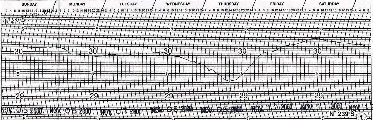
Wooster #16 (Wayne County) Jack Sisler Temperatures for the month were slightly below normal with a monthly mean of 38.8 degrees. Precipitation was over one inch below normal even though there were 11 days with measurable precipitation. Precipitation for the year is over four inches below normal which is not good if we don't see some beneficial precipitation before the ground freezes. The first measurable snowfall for the season occurred on the 20th with 0.2 inch. Kidron #02 (Wayne County) Ron Hahn Both temperature and precipitation averaged below normal in November. Temperatures ran about 2 degrees below the normal while precipitation was 1.76 inches below normal. Snowfall was 0.2 inch above normal. Perrysville #79 (Richland County) Katie Gerwig Average normal temperatures and less than normal precipitation. Very cloudy month with 17 overcast and 10 partly cloudy days. At least a trace of snow on each of 8 days. Very slippery, wet snow on the 29th There was approximately 3 inches of snow 20 miles north at Ashland. Ravenna #101 (Portage County) Rich Rabatin The average wind chill index was 24.2 degrees with the lowest wind chill of 4 degrees on the 22nd. There were 17 days with noteworthy wind chills. We had 3 fog days, with a dense fog advisory on the 8th followed by a thunderstorm watch on the 9th, but no storms at this reporting station. Streetsboro #98 (Portage County) Vance Lunn November this year started out fairly calm and mild. That would change after the 13th, which saw the last 50 degree temperature of the month. A light snow coated the ground the next day. The 17th and 18th saw a light lake effect event of almost an inch. The most spectacular lake effect event of the month occurred several days later on the 20th through 22nd. The 21st saw 5.6 inches of snow. Of that, 5.1 inches fell between the hours of 9am and 12 noon in a single blast. The following day saw another squall over about one hour in the evening. This shorter lasting storm brought 1.8 inches. The total for that event was 8.8 inches. Worth noting is that ice began forming in local small lakes and ponds during this time. Small pieces survived a spell of milder weather before more cold weather allowed for more ice to form by the last day of the month. If the weather holds in December, this would be the earliest that I have seen the seasonal ice cover begin forming. Springfield #1 (Clark County) Dick Groeber This was a month of extremes of temperature and barometric pressure. Overall precipitation, even though falling on half the dates, was below the station averages for both rainfall and snowfall. The high temperature of the month, 77 degrees on the 2nd, was the third warmest over the past 33 years of station records. The warmest was just last year in 1999 at 82 degrees on the 1st. The low of 14 degrees on the 22nd was the fourth lowest of that period. The lowest was +5 degrees in 1976 on the 30th. Overall, the temperature was near the station averages. The low barometer of 29.38 inches was the fifth lowest. The lowest was 29.15 inches set in 1988 on the 5th. Overall, the atmospheric pressure was below the station averages. Kent #53 (Portage County) Eric Wertz) November 2000 ushered in colder than normal temperatures as well as below normal liquid equivalent precipitation. Total snowfall for the month of 4.1 inches was near normal. Measurable liquid equivalent precipitation fell on 15 days with six days seeing measurable snowfall, Due to the absence of any major storm systems no particularly heavy rainfall, snowfall, or thunderstorms were observed. One dense fog advisory was issued on the 8th with a severe thunderstorm watch on the 9th as the most vigorous low pressure system of the month moved through with a reading of 29.39 inches on the 9th and a high wind gust of 32 mph on the 10th. Three fog days were noted. Spring Valley #62 (Greene County) Ed Kramer First major storm of the winter season came on November 8th thu the 9th. See barograph below. The pattern was decidedly changed bringing an end to a mild and pleasant fall. Wind damage was limited to trees and power lines in the area. The shift to a predominant northerly flow dropped Spring Valley temperatures the rest of the month. |
|
Mean Temperatures
|
High Wind Gust
|
Average High Wind Gust
|
| Coldwater #97 |
44.8
|
| Ravenna #101 |
44.6
|
|
Cincinnati #13
|
43.0
|
| Sharonville #43 |
42.8
|
| Spring Valley #62 |
42.6
|
| Stow 1E #105 |
42.5
|
| Chillicothe #40 |
42.2
|
| Cincinnati NWS |
41.7
|
| Port Clinton #14 |
41.4
|
| Centerville #82 |
41.3
|
| Sandusky #4 |
41.3
|
| Cleveland #23 |
41.1
|
| Columbus NWS |
41.0
|
| Springfield #1 |
41.0
|
| Loveland #83 |
40.9
|
| Akron #11 |
40.6
|
| Rockbridge #33 |
40.6
|
| Dayton NWS |
40.4
|
| North Ridgeville #32 |
40.4
|
| Ottawa #15 |
40.3
|
| Lancaster #30 |
40.0
|
| Newcomerstown #106 |
40.0
|
| Oxford |
39.9
|
|
Toledo NWS
|
39.9
|
| Zanesville #48 |
39.9
|
| Cleveland NWS |
39.8
|
| Ada #115 |
39.5
|
| New Philadelphia #58 |
39.5
|
| Perry #38 |
39.5
|
| Perrysville #79 |
39.5
|
| Kidron #2 |
39.4
|
| Lagrange #87 |
39.2
|
| Munroe Falls #25 |
39.2
|
| Alliance #21 |
39.1
|
| Barberton #100 |
39.1
|
| Holgate #8 |
39.1
|
| Kent #22 |
38.9
|
| Sugarcreek #98 |
38.8
|
| Wooster #16 |
38.8
|
| Streetsboro #98 |
38.6
|
| Youngstown NWS |
38.6
|
| Aurora #3 |
38.5
|
| Mansfield NWS |
38.4
|
| Akron-Canton NWS |
38.3
|
| Kent #53 |
38.3
|
| Dayton NWS |
47
|
| Sharonville #43 |
47
|
| Toledo NWS |
46
|
| Cincinnati NWS |
45
|
| Centerville #82 |
43
|
| Columbus NWS |
43
|
| Ottawa #15 |
43
|
| Port Clinton #14 |
43
|
| Oxford #108 |
42
|
| Springfield #1 |
42
|
| Lagrange #87 |
41
|
| Munroe Falls #25 |
41
|
| Sandusky #4 |
40
|
| Wooster #16 |
40
|
| Cleveland NWS |
39
|
| Holgate #8 |
38
|
| Akron-Canton NWS |
37
|
| Mansfield NWS |
37
|
| New Philadelphia #58 |
36
|
| Youngstown NWS |
36
|
| Newcomerstown #106 |
35
|
| Sugarcreek #112 |
34
|
| Kent #53 |
32
|
| Streetsboro #98 |
32
|
| North Ridgeville #32 |
31
|
| Akron #11 |
30
|
| Coldwater #97 |
30
|
| Barberton #100 |
29
|
| Perrysville #79 |
29
|
| Ravenna #101 |
26
|
| Spring Valley #62 |
25
|
| Cleveland #23 |
22
|
| Kidron #2 |
22
|
| Zanesville #48 |
22
|
| Kent #22 |
21
|
| Alliance #21 |
12
|
| Ottawa #15 |
24.2
|
| Port Clinton #14 |
23.4
|
| Lagrange #87 |
22.4
|
| Sandusky #4 |
22.2
|
| Centerville #82 |
19.5
|
| Munroe Falls #25 |
19.4
|
| North Ridgeville #32 |
18.5
|
| Wooster #16 |
18.4
|
| Sugarcreek #112 |
18.0
|
| Kent #53 |
17.4
|
| Newcomerstown #106 |
17.3
|
| Barberton #100 |
16.7
|
| Streetsboro #98 |
16.4
|
| Coldwater #97 |
16.0
|
| Perrysville #79 |
15.4
|
| Akron #11 |
14.0
|
| Spring Valley #62 |
13.5
|
| Cleveland #23 |
12.0
|
| Kent #22 |
11.8
|
| Kidron #2 |
12.0
|
| Alliance #21 |
9.7
|
|
|
|
Weather Station
|
Temperature Max /Min Date
|
Precipitation Total / 24 hour Date
|
Snowfall Total / 24 hour / Max depth
|
| Ada #115 |
73 (2) / - (M)
|
1.45 / - (M)
|
-
|
| Akron #11 |
67 (2) / 16 (23)
|
1.21 / 0.51 (26)
|
T / T / T
|
| Akron-Canton NWS |
66 (2) / 10 (23)
|
1.73 / 0.45 (26)
|
6.7 / 1.8 (-) / 2
|
| Alliance #21 |
68 (2) / 12 (22)
|
1.94 / 0.52 (25)
|
2.5 / 1.8 (20) / 2
|
| Athens #104 |
-
|
-
|
-
|
| Aurora #3 |
66 (2) / 11 (23)
|
2.04 / 0.39 (10)
|
13.2 / 5.9 (M) / 5
|
| Barberton #100 |
66 (9) / 12 (23)
|
1.41 / 0.41 (25)
|
-
|
| Centerville #82 |
79 (2) / 13 (22)
|
2.54 / 0.65 (9)
|
T / T (18) / 0
|
| Chillicothe #40 |
75 (3) / 11 (22)
|
1.17 / 0.33 (9)
|
T / T (M) / 0
|
| Cincinnati #13 |
78 (2) / 18 (22)
|
2.41 / 0.73 (25)
|
T / T (M) / T
|
| Cincinnati NWS |
78 (2) / 13 (22)
|
2.33 / 0.80 (25)
|
0.4 / 0.4 (29) / T
|
| Cleveland NWS |
66 (9) / 13 (23)
|
2.55 / 0.56 (21)
|
11.2 / 7.5 (21) / 5
|
| Cleveland #23 |
68 (2) / 18 (22)
|
2.68 / 0.58 (21)
|
9.5 / 5.8 (21) / 6
|
| Coldwater #97 |
75 (2) / 15 (22)
|
1.36 / 0.52 (9)
|
T / T (M) / 0
|
| Columbus #9 |
-
|
-
|
-
|
| Columbus NWS |
71 (2) / 15 (22)
|
2.13 / 0.90 (10)
|
1.3 / 0.5 (20) / T
|
| Dayton NWS |
74 (2) / 12 (22)
|
2.32 / 1.39 (10)
|
0.5 / 0.5 (29) / 0
|
| Holgate #8 |
73 (2) / 15 (22)
|
2.06 / 0.74 (9)
|
0.7 / 0.4 (17) / T
|
| Kent #22 |
66 (2) / 15 (22,23)
|
1.85 / 0.38 (30)
|
3.7 / 1.1 (M) / 1
|
| Kent #53 |
66 (9) / 15 (22,23)
|
1.81 / 0.33 (25)
|
4.1 / 1.4 (21) / 1
|
| Kidron #2 |
69 (2,3) / 12 (22,23)
|
1.44 / 0.33 (10,25)
|
3.0 / 1.4 (20) / 1
|
| Lagrange #87 |
70 (2) / 06 (23)
|
1.73 / 0.39 (3)
|
2.1 / 1.2 (22) / 1
|
| Lancaster #17 |
-
|
-
|
-
|
| Lancaster #30 |
73 (2) / 11 (22)
|
1.79 / 0.52 (25)
|
1.2 / 0.8 (21) / 1
|
| Loveland #83 |
78 (2) / 14 (22)
|
1.23 / 0.42 (9)
|
T / T (M) / T
|
| Mansfield NWS |
69 (2) / 12 (22)
|
2.02 / 0.59 (10)
|
8.7 / 4.4 (29) / 4
|
| Munroe Falls #25 |
67 (2) / 14 (23)
|
2.08 / 0.41 (30)
|
3.1 / 0.7 (22,29,30) / 1
|
| Newcomerstown #99 |
71 (2) / 13 (22,23)
|
1.85 / 0.57 (26)
|
T / T (M) / T
|
| Newcomerstown #106 |
71 (2) / 14 (22,23)
|
1.46 / 0.37 (25)
|
2.1 / - (M) / 1
|
| New Philadelphia #58 |
67 (2,3) / 12 (22)
|
1.44 / 0.49 (25)
|
1.1 / 0.6 (20) / 0
|
| North Ridgeville #32 |
68 (1,2) / 06 (22)
|
2.03 / - (M)
|
7.2 / 4.0 (21) / 5
|
| Ottawa #15 |
78 (2) / 14 (22)
|
1.35 / 0.29 (9)
|
0.7 / 0.4 (21) / T
|
| Oxford #108 |
76 (2) / 16 (22)
|
1.03 / 0.60 (25)
|
-
|
| Perry #38 |
65 (2,9) / 19 (21,22)
|
4.21 / 0.63 (15)
|
26.0 / 8.0 (M) / 13
|
| Perrysville #79 |
68 (3) / 10 (22)
|
1.78 / 0.37 (10)
|
2.2 / 1.0 (21,29) / 1
|
| Port Clinton #14 |
69 (2) / 19 (22)
|
1.48 / 0.42 (26)
|
0.1 / 0.1 (M) / 0
|
| Ravenna #101 |
66 (2) / 25 (22)
|
2.17 / 0.38 (25)
|
5.8 / 2.8 (21) / 4
|
| Rockbridge #33 |
73 (2) / 13 (22)
|
1.97 / 0.45 (9)
|
2.5 / 1.8 (21) / 1
|
| Rocky River #51 |
-
|
2.07 / 0.60 (21)
|
8.5 / 6.0 (21) / -
|
| Sabina #113 |
-
|
2.03 / 0.75 (9)
|
-
|
| Sandusky #4 |
72 (2) / 18 (22)
|
1.49 / 0.36 (9)
|
1.5 / 1.2 (21) / 1
|
| Sharonville #43 |
77 (M) / 19 (M)
|
2.53 / 0.96 (M)
|
T / T (M) / T
|
| Springfield #1 |
77 (2) / 14 (22)
|
2.18 / 0.87 (9)
|
0.9 / 0.7 (20) / 1
|
| Spring Valley #62 |
78 (2) / 14 (22)
|
2.20 / 0.59 (9)
|
0.0 / 0.0 (-) / 0
|
| Stow #105 |
70 (2) / 19 (22)
|
-
|
3.6 / 1.1 (22) / 1
|
| Streetsboro #98 |
68 (2) / 15 (23)
|
2.52 / 0.57 (25)
|
12.5 / 5.7 (22) / 6
|
| Sugarcreek #112 |
68 (2,3) / 13 (22)
|
1.10 / 0.26 (25)
|
1.1 / 0.5 (21) / T
|
| Toledo #66 |
-
|
-
|
-
|
| Toledo NWS |
73 (2) / 14 (23)
|
1.42 / 0.35 (9)
|
1.2 / 0.3 (29) / 1
|
| Wooster #16 |
68 (2) / 11 (23)
|
1.36 / 0.41 (10)
|
1.5 / 1.1 (29) / 1
|
| Youngstown NWS |
66 (8) / 15 (23)
|
1.76 / 0.37 (10)
|
5.9 / 1.9 (22) / 2
|
| Zanesville #48 |
67 (9) / 14 (22)
|
1.39 / 0.42 (25)
|
T / T (21) / -
|