|
May 2001 Ohio Weather Observer Network Weather summaries, Station Data and Network News E-Mail: lrhuff@megsinet.net www.ohioweather.net |
|
Weather Station Summaries
Rain amounts exceed 11 inches in Pickaway County. Tornadoes touch down in the northeast section. |
| Springfield 2N #1 (Clark County) Dick Groeber - Both temperature and rainfall values were significant this month. The temperatures ranged well above the station's 33 year averages for the first half of the month and then fell to near to below those averages for the last half. High temperatures in the middle to upper 80s were common for the first half approaching records highs. By the end of the month, around the Memorial Day period, low temperatures in the upper 40s were common. Because of the extreme warmth of the first half of May, the overall values were above the 33 year average. The month began without rainfall for the first six dates. A significant change to the dry period occurred from the 10th through the 27th with over a two week period of nearly daily and sometimes heavy rainfall. This ended the dry period of the first four months of the year. This period made the month total of 6.96 inches which was the 7th wettest of the past 33 years. The wettest was 10.21 inches recorded here in May of 1981. The next wettest was 10.07 inches recorded in 1968. The last wet May locally was in 1998 with 7.25 inches. The first half of the month was dominated by high atmospheric pressure while the last half by low. This would account for the wetness of the last half of the month.
Perrysville 4W #79 (Richland County) Katie Gerwig - The month of May was wetter than normal by approximately 1 inch with precipitation falling on 17 days. Temperatures averaged slightly above normal with the warmest readings from the 1st to the 11th. Six days had thunderstorms, none severe in this area. Cincinnati 5NW #13 (Hamilton County) Ronald E. Rothhaas Jr - Perception is not always reality. So it is with May 2001. Ask most people in Cincinnati and they will tell you May was cold and very wet. In reality, it was 2.1 F above normal and rainfall was only 0.90 inch above normal. However, measurable rain fell on 15 of 31 days with at least a trace on 19 days. Measurable rain fell on all but one day from the 16th to the 27th as a cut off low sat over the area.. On 6 of the last 10 days of the month the high was below 70 with a high of only 58 on the 23rd, leaving an impression that the whole month was cool. In a year when the precipitation deficit had topped 8 inches, the persistent rainfall of late May made it seem like a rain forest. However, annual rainfall was still quite short by month's end. On May 15 to 19, a very heavy rainfall event covered the eastern parts of the area but mainly missed my station. Accumulated rainfall of 3 to 8 inches fell is an area from southwest Michigan to eastern Kentucky. A graphic of accumulated rainfall in this event can be accessed through the homepage of the NWS Wilmington. The heavy rain upstream drove up the Ohio River causing minor lowland flooding and canceling concerts at the Riverbend Music Center. Interestingly, I have yet to record 1.00 inches of rain in any 24 hour period this year. Kidron 1N #2 (Wayne County) Ronald A. Hahn - May was divided into two major regimes. The first 11 days saw summer-like readings with 6 of those days having highs in the 80s. Cool weather dominated thereafter with a couple exceptions. Temperatures averaged 1.9 degrees above normal. Precipitation was about normal (0.05 above) at 4.25 inches. We had a total of seven 80 degree days in May and that makes 12 for the year with the five in April. Wooster 7N #16 (Wayne County) Jack Sisler - Temperatures were about two degrees above normal with the warmer temperatures occuring during the first half of the month. Precipitation was almost four tenths above normal although it seemed more with 18 days having a trace or more. Perry 3SE #38 (Lake County) Christopher Cintula - Frost on the 31st (morning) was the latest on record. It was mosty on roof tops and only a little on the grass. The frost did not do much damage. Spring Valley 2E #62 (Greene County) Ed Kramer - Our drought was dramatically ended by mid May with cool and wet conditions. Stunted soybean and corn crops struggled with ponding and soil temperatures which hit a low of 53 degrees (six inch depth) on May 28th. This was the lowest soil temperature at this station and was 7 degrees below normal. Of some note was the amazing accuracy of the reworked U.S. mid-range forecast. The new MRF pegged the block a week before the 15th. Very few took the MRF omega block seriously or even considered the longevity of the "Chicago Monster". Kent 2W #53 (Portage County) Eric Wertz - May 2001 saw normal precipitation and normal temperatures. There were 15 days of measurable precipitation. The period of the 21st through the 27th saw daily rainfall and some thunderstorms as a persistent low pressure system and cool temperatures plaqued the region. Thunderstorms occurred on 5 days with scattered reports of severe weather on the 21st with a tornado watch and warning resulting for Summit County. A total of four watches/warnings/advisories were issued during the month. High wind gusts were notably lower this month with the high wind gust being only 29 mph on the 26th. A record low temperature of 35 degrees was set on the 31st. Total rainfall was 2.81 inches with four fog days observed.
|
|
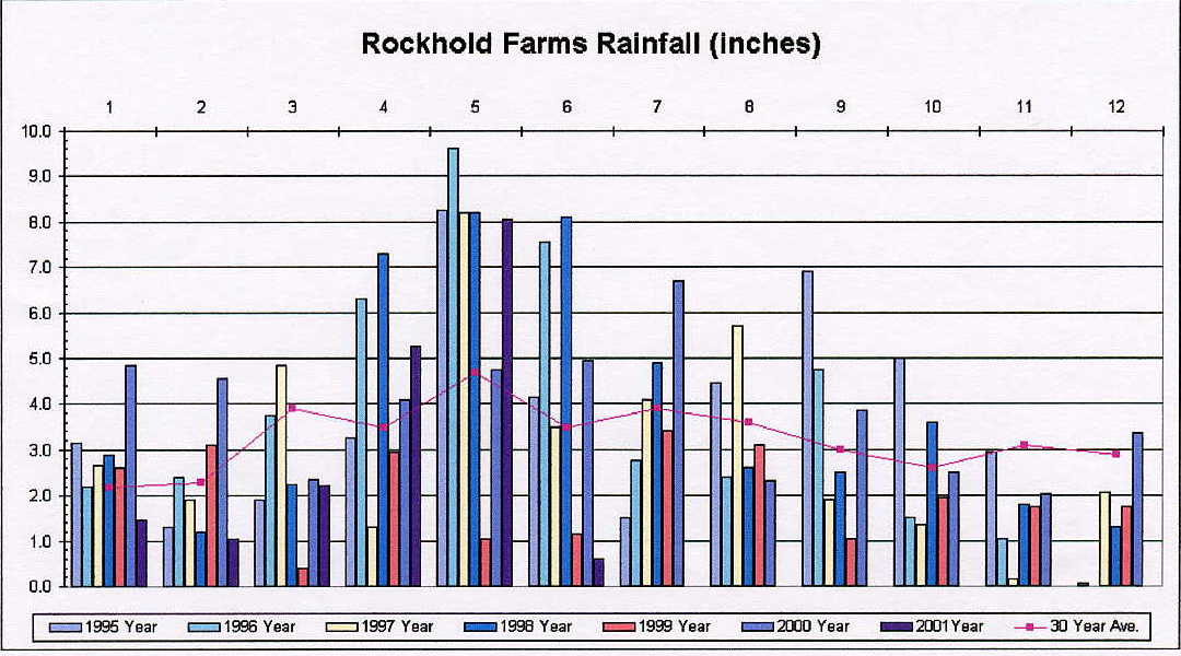
Sabina (Fayette/Clinton County) Ron Rockhold - OWON #113 30 Year Average Precipitation ... 1960-1990 |
|
May 2001 weather extremes from all available weather stations including the OWON
|
|
-
|
READING
|
DATE
|
STATION (s)
|
|
Highest Temperature
|
91
|
unknown
|
Lancaster 4N (Fairfield County)
|
|
Lowest Temperature
|
29
|
13th
|
Aurora 3S (Portage County)
|
|
Highest Precipitation
|
11.70
|
-
|
Commercial Point (Pickaway County)
|
|
Lowest Precipitation
|
2.59
|
-
|
Stow 1SE (Summit County)
|
|
Highest Snowfall
|
0
|
-
|
-
|
|
Highest Wind Gust
|
55
|
21st
|
Columbus NWS
|
|
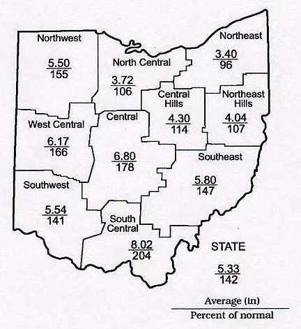
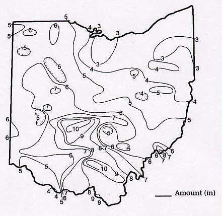
May 2001 Precipitation Maps
Courtesy of the Ohio Department of Natural Resources David H. Cashell Scott Kirk |
|
May 2001 Ohio Weather Data
|
|
Station
|
Max / Min Temperature
|
Mean Temp
|
Precipitation and Max 24 hr precipitation
|
Snowfall and Maximum 24 hr snow
|
High WindGust and Average High Wind Gust
|
High & Low Barometer
|
|
Ada #115
|
83 (4) / 41 (13)
|
62.4
|
4.33 / 0.70 (26)
|
-
|
-
|
-
|
|
Akron-Canton NWS
|
82 (4) / 35 (13)
|
59.1
|
4.29 / 1.33 (22)
|
0
|
32 (26)
|
30.30 (13) / 29.58 (21)
|
|
Alliance 7S #21
|
-
|
-
|
-
|
-
|
-
|
-
|
|
Athens 1S
|
-
|
-
|
-
|
-
|
-
|
-
|
|
Aurora 3S #3
|
83 (1) / 29 (13)
|
59.2
|
3.05 / 0.76 (12)
|
0
|
-
|
-
|
|
84 (3) / 33 (13)
|
60.3
|
2.65 / 0.45 (11)
|
-
|
32 (25) / 16.0
|
30.30 (13) / 29.71 (22)
|
|
|
88 (6) / 40 (13)
|
64.3
|
5.49 / 1.88 (18)
|
0
|
30 (17) / 17.8
|
30.33 (13) / 29.59 (21)
|
|
|
Chillicothe 3S #40
|
-
|
-
|
6.22 / 2.00 (19)
|
0
|
-
|
-
|
|
Cincinnati 5NW #13
|
84 (4,6,11) / 46 (25)
|
65.0
|
5.18 / 0.86 (18)
|
T (hail)
|
E35 (25) / -
|
E30.15 (1) /E29.48 (22)
|
|
Cincinnati NWS
|
86 (6) / 43 (25)
|
64.2
|
5.16 / 1.22 (19)
|
0
|
41 (17)
|
-
|
|
Cleveland NWS
|
84 (1) / 33 (13)
|
60.0
|
3.84 / 1.96 (22)
|
0
|
43 (11)
|
-
|
|
Columbus 5NW #9
|
86 (3) / 39 (14)
|
63.1
|
6.58 / 1.44 (16)
|
0
|
31 (17)
|
-
|
|
Columbus NWS
|
86 (3) / 42 (14)
|
63.5
|
7.03 / 1.23 (8)
|
0
|
55 (21)
|
-
|
|
Dayton NWS
|
84 (15) / 41 (13)
|
63.5
|
4.54 / 1.09 (18)
|
0
|
41 (17)
|
-
|
|
Holgate 1SE #8
|
86 (4) / 41 (13)
|
62.5
|
5.26 / 0.82 (15)
|
0
|
27 (7)
|
30.44 (13) / 29.74 (21)
|
|
85 (3) / 31 (13)
|
59.3
|
3.06 / 0.66 (21)
|
0
|
18 (26) / 11.6
|
30.27 (7) / 29.59 (21)
|
|
|
Kent 2W #53
|
84 (3) / 30 (13)
|
58.8
|
2.81 / 0.47 (21)
|
0
|
29 (26) / 17.1
|
30.30 (7) / 29.61 (22)
|
|
Kidron 1N #2
|
87 (3) / 34 (13)
|
61.6
|
4.25 / 0.92 (11)
|
0
|
13 (1,13) / 8.0
|
30.34 (7,13) / 29.62 (21)
|
|
Lagrange 2SW #87
|
86 (4) / 36 (13)
|
61.2
|
4.27 / 1.70 (21)
|
0
|
30 (27) / 19.8
|
30.30 (13) / 29.56 (21)
|
|
Lancaster 4N #17
|
91 (x) / 43 (x)
|
-
|
6.22 / 1.29 (x)
|
-
|
37 (11)
|
-
|
|
Lancaster 1E #30
|
-
|
-
|
-
|
-
|
-
|
-
|
|
Loveland 1N #83
|
-
|
-
|
-
|
-
|
-
|
-
|
|
Mansfield NWS
|
82 (3) / 34 (13)
|
59.6
|
3.77 / 0.61 (12)
|
0
|
46 (25)
|
30.33 (13) / 29.55 (21)
|
|
86 (3) / 31 (13)
|
59.6
|
2.64 / 0.63 (22)
|
0
|
28 (25) / 18.5
|
30.28 (13) / 29.64 (21)
|
|
|
Newcomerstown 1S #106
|
87 (3) / 34 (13,14)
|
60.1
|
3.37 / 0.91 (22)
|
0
|
33 (25) / 17.2
|
30.31 (10,11) /29.66 (21)
|
|
New Philadelphia 1NW #58
|
83 (3) / 33 (13)
|
57.1
|
4.50 / 1.65 (21)
|
0
|
22 (26) -
|
30.19 (7) / 29.65 (21)
|
|
North Ridgeville 1N #32
|
89 (4) / 32 (13)
|
61.3
|
2.84 / 0.71 (21)
|
0
|
38 (x) / 18.3
|
30.29 (13) / 29.50 (21)
|
|
Ottawa 4E #15
|
85 (3,4) / 39 (13)
|
62.4
|
5.20 / 1.03 (15)
|
0
|
35 (27) / 22.5
|
30.44 (7) / 29.57 (7,28)
|
|
Oxford #108
|
-
|
-
|
-
|
-
|
-
|
-
|
|
Perry 3SE #38
|
82 (1) / 34 (13)
|
58.4
|
3.33 / 1.27 (12)
|
0
|
-
|
-
|
|
Perrysville 4W #79
|
84 (3) / 34 (13)
|
60.3
|
4.93 / 0.73 (21)
|
0
|
29 (27) / 12.6
|
-
|
|
Port Clinton 3W #14
|
86 (3,4) / 45 (13)
|
62.5
|
2.87 / 0.62 (7)
|
0
|
39 (25) / 23.4
|
30.32 (13) / 29.50 (21)
|
|
83 (10) / 38 (13)
|
61.0
|
2.62 / 0.70 (22)
|
0
|
20 (21) / 13.2
|
30.56 (12) / 29.73 (21)
|
|
|
Rockbridge 4W #33
|
86 (3) / 40 (13)
|
62.3
|
5.74 / 1.51 (18)
|
0
|
-
|
-
|
|
Rocky River 1W #51
|
-
|
-
|
3.36 / 1.50 (21)
|
0
|
-
|
-
|
|
Sabina #113
|
-
|
-
|
8.04 / 2.40 (18)
|
-
|
-
|
-
|
|
Sandusky 1N #4
|
85 (4) / 41 (13)
|
61.9
|
2.61 / 0.83 (16)
|
0
|
30 (21) / 19.9
|
30.34 (13) / 29.55 (21)
|
|
Sharonville 2NE #43
|
87 (x) / 43 (x)
|
65.4
|
7.12 / 1.30 (x)
|
0
|
25 (21,22) / -
|
30.34 (13) / 29.61 (21)
|
|
Springfield 2N #1
|
89 (3,4) / 42 (13)
|
65.3
|
6.96 / 1.57 (15)
|
0
|
46 (7) / 20.0
|
30.28 (13) / 29.65 (27)
|
|
Spring Valley 2E #62
|
86 (3) / 43 (14)
|
64.1
|
5.77 / 1.71 (19)
|
0
|
15 (7) / 10.2
|
30.35 (9) / 29.60 (21)
|
|
Stow 1SE #105
|
87 (4) / 37 (13)
|
64.2
|
2.59 / 0.59 (22)
|
0
|
-
|
30.15 (7,13)/29.50 (21,22)
|
|
-
|
-
|
-
|
-
|
-
|
-
|
|
|
Sugarcreek 2SW #112
|
84 (3,4) / 33 (13,14)
|
59.7
|
3.86 / 1.40 (21)
|
0
|
25 (26) / 14.9
|
30.30 (8,13) / 29.73 (21)
|
|
Toledo 5NE #66
|
86 (3) / 38 (13)
|
61.5
|
3.75 / 1.09 (15)
|
0
|
42 (11) / -
|
30.32 (5) / 29.48 (21)
|
|
Toledo NWS
|
86 (4) / 38 (13)
|
61.4
|
5.06 / 1.51 (16)
|
0
|
45 (25)
|
30.33 (13) / 29.47 (21)
|
|
Van Wert #86
|
89 (3) / 43 (13)
|
65.2
|
5.90 / 1.45 (24)
|
0
|
36 (27) / 23.0
|
30.29 (13) / 29.52 (21)
|
|
84 (3) / 33 (13)
|
60.1
|
4.09 / 0.76 (12)
|
0
|
32 (27) / 17.5
|
30.29 (13) / 29.59 (22)
|
|
|
Youngstown NWS
|
84 (4) / 33 (13)
|
58.8
|
2.70 / 0.89 (22)
|
0
|
43 (25)
|
30.33 (7) / 29.64 (21)
|
|
Zanesville 6N #48
|
85 (3) / 38 (14)
|
60.6
|
5.39 / 0.95 (18)
|
0
|
19 (11,25)
|
30.31 (13) / 29.60 (21)
|
|
|
NORTHEAST OHIO CHAPTER
THE AMERICAN METEOROLOGICAL SOCIETY MEETING NOTICE SATURDAY, AUGUST 18, 2001 11:00 A.M. KENT STATE UNIVERSITY MCGILVREY HALL, ROOM 302 (CORNER OF SOUTH LINCOLN STREET AND EAST SUMMIT STREET) KENT, OHIO GUEST SPEAKER: DAN MCCARTHY WARNING COORDINATION METEOROLOGIST STORM PREDICTION CENTER NORMAN, OKLAHOMA TOPIC OHIO TORNADOES |