|
June 2001 Ohio Weather Observer Network Weather summaries, Station Data and Network News E-Mail: lrhuff@megsinet.net www.ohioweather.net |
|
Weather Station Summaries
|
| Springfield 2N #1 (Clark County) Dick Groeber - Locally, June began cool and wet and ended warm and dry. Temperatures for the first week were cool but gradually warmed as the month progressed. Overall, the temperatures were above the station's 33 year averages. Rainfall occurred during the first three weeks, leaving the last week dry. The strongest storms occurred during the middle of the month. Many strong to severe thunderstorms were reported in the vicinity but missing this station. Thus, the month's total was below the station's 33 year averages. The atmospheric pressure began dominatly low but gradually rose.
Perrysville 4W #79 (Richland County) Katie Gerwig - June rainfall was 3/4 - 1 inch over normal with precipitation recorded on 14 days. Thunder was heard on 8 days. Temperatures were normal. Ravenna 1E #101 (Portage County) Rich Rabatin - My station had one thunderstorm warning on the 20th and one thunderstorm watch on the 21st. The 3.56 inches of rain for the month is about 0.38 inch below normal. Wooster 7N #16 (Wayne County) Jack Sisler - Recorded the first 90 degree reading on the 13th since August 1, 1999. Temperatues were almost one degree above normal with three 90 degree days or better for the month. After starting to recover from the precipitation deficit the previous two months, precipitation for June was 1.18 inches below normal. Most of it fell during the first half of the month. Winds were fairly light for the month. Cincinnati 5NW #13 (Hamilton Couny) Ronald E. Rothhaas Jr. - June was essentially normal with periods of summer heat and thunderstorms but little extraordinary. The first 4 days were very cool with respective highs on the first to the fourth of only 65,69,65 and 60. 1.45 inches of rain fell over the 4 day period. Although we were 1.06 inches above normal for the month, maximum 24 hour rainfall was only 0.89 inch on the 6th. Remarkably, we have not had 1 inch of rain in 24 hours since December. Kidron 1N #2 (Wayne County) Ronald A. Hahn - Despite the cool start to the month, June ended up 0.8 of a degree above normal in temperature with 3 days of highs at or above 90 degrees. The high of 91 degrees on the 13th was a new record for that date here. Rainfall, however, was 1.42 inches below normal. For the year thus far, rainfall at Kidron stands at 14.86 inches, minus 3.87 inches below normal. Toledo 5NE #66 (Lucas County) Mike Bielski - The month was slightly above average. Months average was 69.2 which was + 1.3 degrees above normal. The were 3 days 90 degrees or higher. There were 9 days with measurable precipitation. Precipitation was short for the month by - 1.36. Year to date thru June we have a shortage of 4.46 inches. We had 2 thunderstorms days, and on 6/19 a thunderstorm with pea size hail and a wind gust to 45 mph, with heavy rain of 0.62 in 25 minutes. Kent 2W #53 (Portage County) Eric Wertz - June 2001 saw normal precipitation and normal temperatures. Despite the fact that there were 8 thunderstorm days at Kent 2W, no unusually heavy rainfall or high winds were noted. The only notable strong thunderstorm activity in the region occurred on the 20th and 21st as a strong cold front moved slowly across the Buckeye State. Only one severe thunderstorm warning (on the 20th) and one severe thunderstorm watch (on the 21st) were issued. Heaviest 24-hour rainfall was 0.72 inch on the 30th. A record low temperature of 41 degrees was observed on the 5th. Very warm conditions, with temperatures of 85 degrees and higher, were recorded on the 12th through 15th. Fog occurred on the 12th and 21st. The highest wind was 21 mph on the 1st and 16th.
|
| I am very pleased and excited to announce a new direction for the Ohio Weather Observer Network. I have asked Dr. Tom Schmidlin, Kent State University, Department of Geography & Climatology, to take over my duties for the OWON. I have come to the point that I want to spend more time attending to my own weather station plus I have lost the required drive to continue the administration of the OWON. Tom will have Scott Sheridan, Ph.D., Assistant Professor in Climatology, handle the actual adminstration of the network. The actual change-over will take place at the end of September. I will continue to handle the monthly summaries through the September data. I will continue my involvement with the network after September with my own regular reporting of Munroe Falls weather data, like all the rest of you. Further details will come your way as they become available. I think that all of you will find this change a refreshing move forward for the Ohio Weather Observer Network.
Larry Huff |
|
June 2001 weather extremes from all available weather stations including the OWON
|
|
-
|
READING
|
DATE
|
STATION (s)
|
|
Highest Temperature
|
96
|
14
|
Streetsboro 2N (Portage County)
|
|
Lowest Temperature
|
38
|
5th
|
Aurora 3S (Portage County)
|
|
Highest Precipitation
|
5.60
|
-
|
Marietta State Nursery (Washinton County) Reported by ODNR
|
|
Lowest Precipitation
|
0.98
|
-
|
Sandusky (Erie County) Reported by Ohio Dept Natural Resources (ODNR)
|
|
Highest Snowfall
|
0
|
-
|
-
|
|
Highest Wind Gust
|
56
|
21
|
Cincinnati NWS (Hamilton County)
|
|
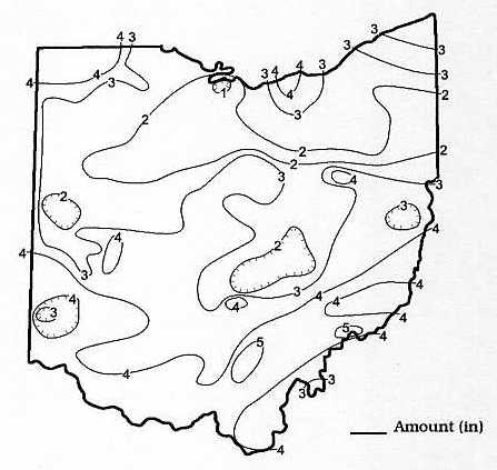
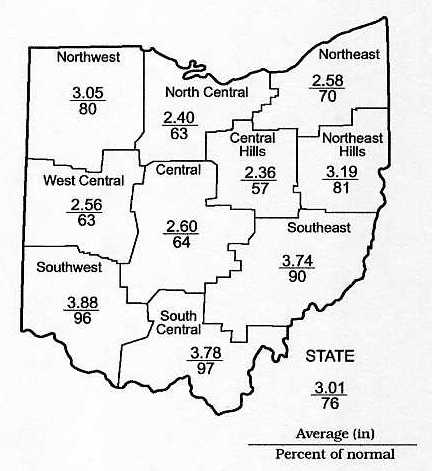
June 2001 Precipitation Maps
Courtesy of the Ohio Department of Natural Resources David H. Cashell Scott Kirk |
|
June 2001 Ohio Weather Data
|
|
Station
|
Max / Min Temperature
|
Mean Temp
|
Precipitation and Max 24 hr precipitation
|
Snowfall and Maximum 24 hr snow
|
High WindGust and Average High Wind Gust
|
High & Low Barometer
|
|
Ada #115
|
-
|
-
|
-
|
-
|
-
|
-
|
|
Akron-Canton NWS
|
88 (19) / 42 (4)
|
68.0
|
2.93 / 0.78 (22)
|
0
|
30 (21) / -
|
30.36 (27) / 29.57 (2)
|
|
Alliance 7S #21
|
-
|
-
|
-
|
-
|
-
|
-
|
|
Athens 1S
|
-
|
-
|
-
|
-
|
-
|
-
|
|
Aurora 3S #3
|
89 (13,14,19,29) / 38 (5)
|
66.4
|
2.60 / 0.64 (30)
|
0
|
-
|
-
|
|
92 (14) / 45 (4)
|
68.4
|
2.41 / 0.45 (1)
|
-
|
19 (3) / 12.0
|
30.36 (26) / 29.63 (1)
|
|
|
93 (19) / 48 (4)
|
70.7
|
3.54 / 0.93 (13)
|
0
|
28 (15) / 16.4
|
30.40 (27) / 29.60 (2)
|
|
|
Chillicothe 3S #40
|
90 (13,16,20) / -
|
-
|
3.12 / 0.75 (22)
|
0
|
-
|
-
|
|
Cincinnati 5NW #13
|
90 (12,14,15) / 52 (2,3,9)
|
70.8
|
4.90 / 0.89 (6)
|
0
|
-
|
-
|
|
Cincinnati NWS
|
90 (19) / 47 (2)
|
69.7
|
4.45 / 1.92 (6)
|
0
|
56 (21) / -
|
30.29 (26) / 29.57 (2)
|
|
Cleveland NWS
|
91 (15) / 44 (5)
|
68.0
|
3.96 / 1.40 (22)
|
0
|
35 (2) / -
|
30.37 (27) / 29.55 (2)
|
|
Columbus 5NW #9
|
92 (15) / 47 (4)
|
70.3
|
3.39 / 0.95 (1)
|
0
|
30 (15)
|
-
|
|
Columbus NWS
|
92 (19) / 48 (4)
|
71.1
|
2.30 / 0.58 (1)
|
0
|
38 (21)
|
30.32 (26) / 29.54 (2)
|
|
Dayton NWS
|
90 (19) / 48 (4)
|
69.6
|
2.91 / 0.81 (6)
|
0
|
38 (15)
|
30.33 (26) / 29.58 (2)
|
|
Ellet 1NW #118
|
88 (14) / 45 (4)
|
67.6
|
1.77 / 0.50 (30)
|
0
|
17 (17) / -
|
30.43 (26) / 29.79 (1)
|
|
Holgate 1SE #8
|
-
|
-
|
-
|
0
|
-
|
-
|
|
90 (14,19) / 42 (4,5)
|
67.1
|
3.42 / 1.16 (30)
|
0
|
13 (2,12)/10.0
|
30.34 (27) / 29.55 (2)
|
|
|
Kent 2W #53
|
89 (14) / 41 (5)
|
66.4
|
2.58 / 0.72 (30)
|
0
|
21 (1,16) / 15.4
|
30.39 (27) / 29.57 (2)
|
|
Kidron 1N #2
|
91 (13,14) / 44 (4)
|
69.3
|
2.40 / 0.65 (6)
|
0
|
12 (1) / 6.0
|
30.40 (27) / 29.60 (2)
|
|
Lagrange 2SW #87
|
94 (15) / 47 (9)
|
68.9
|
4.54 / 1.10 (21)
|
0
|
36 (30) / 16.7
|
30.34 (27) / 29.54 (2)
|
|
Lancaster 4N #17
|
93 (x) / 54 (x)
|
-
|
2.96 / 0.80 (x)
|
-
|
36 (12) / -
|
-
|
|
Lancaster 1E #30
|
-
|
-
|
-
|
-
|
-
|
-
|
|
Loveland 1N #83
|
-
|
-
|
-
|
-
|
-
|
-
|
|
Mansfield NWS
|
90 (19) / 40 (4)
|
67.6
|
3.15 / 0.66 (6)
|
0
|
32 (27) / -
|
30.36 (27) / 29.54 (2)
|
|
90 (14,15) / 43 (4)
|
66.8
|
3.07 / 0.68 (30)
|
0
|
25 (17) / 15.9
|
30.33 (27) / 29.61 (2)
|
|
|
Newcomerstown 1S #106
|
90 (14,15,19) / 42 (4)
|
68.9
|
1.72 / 0.61 (6)
|
0
|
33 (1) / 16.2
|
30.30 (26) / 29.60 (2)
|
|
New Philadelphia 1NW #58
|
88 (13) / 42 (4)
|
64.3
|
2.45 / 1.00 (6)
|
0
|
26 (12) / -
|
30.25 (27) / 29.62 (2)
|
|
North Ridgeville 1N #32
|
95 (14,19) / 42 (4,5)
|
69.4
|
3.66 / 1.12 (22)
|
0
|
28 (2) / 15.3
|
30.32 (27) / 29.48 (2)
|
|
Ottawa 4E #15
|
91 (13) / 42 (4)
|
69.0
|
2.62 / 0.55 (2)
|
0
|
31 (15) / 18.0
|
30.28 (28) / 29.30 (2,3)
|
|
Oxford #108
|
-
|
-
|
-
|
-
|
-
|
-
|
|
Perry 3SE #38
|
90 (29) / 41 (5)
|
66.8
|
2.31 / 0.42 (16)
|
0
|
-
|
-
|
|
Perrysville 4W #79
|
90 (19) / 40 (4)
|
67.4
|
4.30 / 1.30 (6)
|
0
|
20 (1) / 10.6
|
-
|
|
Port Clinton 3W #14
|
94 (15) / 47 (4)
|
70.4
|
1.42 / 0.65 (3)
|
0
|
55 (19) / 20.4
|
30.35 (27) / 29.50 (2)
|
|
94 (19) / 47 (5)
|
69.4
|
3.56 / 1.09 (22)
|
0
|
28 (22) / 13.7
|
30.36 (28) / 29.68 (2)
|
|
|
Rockbridge 4W #33
|
91 (19) / 47 (3)
|
69.5
|
4.06 / 1.31 (21)
|
0
|
-
|
-
|
|
Rocky River 1W #51
|
-
|
-
|
4.51 / 1.77 (21)
|
0
|
-
|
-
|
|
Sabina #113
|
-
|
-
|
5.23 / 2.20 (6)
|
-
|
-
|
-
|
|
Sandusky 1N #4
|
93 (19) / 47 (4)
|
70.2
|
1.53 / 0.36 (15)
|
0
|
27 (19) / 17.3
|
30.37 (27) / 29.53 (2)
|
|
Sharonville 2NE #43
|
91 (19) / 51 (2)
|
71.5
|
5.17 / 1.94 (6)
|
0
|
27 (12) / -
|
30.37 (27) / 29.62 (2)
|
|
Springfield 2N #1
|
95 (13) / 49 (2)
|
71.3
|
2.89 / 0.85 (24)
|
0
|
28 (12) / 14.0
|
30.34 (27) / 29.54 (2
|
|
Spring Valley 2E #62
|
90 (19) / 50 (2,9)
|
69.6
|
3.47 / 0.83 (22)
|
0
|
16 (21) / 7.7
|
30.40 (14) / 29.60 (2)
|
|
Stow 1SE #105
|
94 (14) / 47 (4)
|
68.9
|
3.02 / 0.62 (30)
|
0
|
-
|
30.50 (24) / 30.06 (30)
|
|
96 (14) / 43 (4,5)
|
67.5
|
2.74 / 0.72 (27)
|
0
|
23 (11) / 14.5
|
-
|
|
|
Sugarcreek 2SW #112
|
88 (13,14,15) / 40 (4)
|
67.5
|
2.29 / 0.61 (12)
|
0
|
23 (1) / 14.1
|
30.42 (26) / 29.67 (2)
|
|
Tiltonsville #117
|
92 (13) 49 (4)
|
70.2
|
3.91 / 1.18 (1)
|
0
|
31 (21) / -
|
30.41 (17) / 29.61 (2)
|
|
Toledo 5NE #66
|
92 (15) / 45 (4)
|
69.2
|
2.75 / 0.65 (19)
|
0
|
45 (19) / -
|
30.36 (27) / 29.48 (2)
|
|
Toledo NWS
|
92 (15) / 44 (4)
|
68.7
|
2.87 / 0.80 (15)
|
0
|
48 (19) / -
|
30.34 (27) / 29.49 (2)
|
|
Van Wert #86
|
95 (14) / 45 (4)
|
72.0
|
2.00 / 0.64 (5)
|
0
|
42 (15) / 20.0
|
30.31 (27) / 29.52 (2)
|
|
91 (14) / 41 (4)
|
67.6
|
2.17 / 0.58 (2)
|
0
|
25 (1) / 16.2
|
30.33 (26) / 29.60 (2)
|
|
|
Youngstown NWS
|
89 (29) / 44 (9)
|
66.8
|
1.89 / 0.42 (1)
|
0
|
29 (30)
|
30.37 (27) / 29.58 (2)
|
|
Zanesville 6N #48
|
88 (19) / 45 (4)
|
68.4
|
1.84 / 0.63 (6)
|
0
|
15 (12) / -
|
30.38 (27) / 29.60 (2)
|
|
|
NORTHEAST OHIO CHAPTER
THE AMERICAN METEOROLOGICAL SOCIETY MEETING NOTICE SATURDAY, AUGUST 18, 2001 11:00 A.M. KENT STATE UNIVERSITY MCGILVREY HALL, ROOM 302 (CORNER OF SOUTH LINCOLN STREET AND EAST SUMMIT STREET) KENT, OHIO GUEST SPEAKER: DAN MCCARTHY WARNING COORDINATION METEOROLOGIST STORM PREDICTION CENTER NORMAN, OKLAHOMA Topic: OHIO TORNADOES |