
|
July 2001 Ohio Weather Observer Network Weather summaries, Station Data and Network News E-Mail: lrhuff@megsinet.net www.ohioweather.net |
|
Weather Station Summaries
|
| Springfield 2N #1 (Clark County) Dick Groeber - Locally, temperatures began cool with the month low of 50 degrees recorded just before the 4th of July holiday on the 2nd. Two warm periods were noted. The first was a short three-day period between the 8th and the 10th. The second was a longer seven-day period from the 19th through the 25th marked by haze and high relative humidity values typical of the "dog days" of the middle to the late summer. Because the first half of the month saw below normal values, the overall month was just about normal. Rainfall was the big story. There were 13 days of measurable rainfall and nine with thunderstorms. Two dates had small hail. The heaviest storm was at the end of the month on the 29h with 3.35 inches of rain falling from 5:00 A.M. to 11:30 A.M. amid two heavy thunderstorms. Remarkably, little damage or flooding was noted. this was the heaviest one-day total for any July of record here and only the 5th heaviest any date since records began here in 1954. The heaviest was 5.20 inches recorded June 25, 1971. This nearly doubled the monthly total to date at 8.02 inches which ranked as 2nd to 8.37 inches recorded in 1990.
Perrysville 4W #79 (Richland County) Katie Gerwig - Dry is the word for July 2001. According to Cleveland media, driest July since 1931 with 1.01 inches here. There were 4 thunderstorm days before the 9th but from the 11th to the 31st only 0.06 inch fell. Temperatures averaged normal although 5 days saw 90 degrees or above. The last 17 days had highs of 80 degrees or above. Only one overcast day. Wooster 7N #16 (Wayne County) Jack Sisler - Monthly mean temperatures were slightly above normal with five days of 90 degree or above for maximum temperatures. Precipitation for the month was 1.15 inches, almost three inches below normal for the month and over six inches below normal for the year. No records were set for least amount of precipitation for July (record is 1.03 inches in July 1991). Aurora 3S #3 (Portage County) Olaf Stackelberg - 96 degrees on the 24th tied the previous station record on July 14 and 15, 1995. Records began September 1991. Cincinnati 5NW #13 (Hamilton County) Ronald E. Rothhaas Jr. - After months of seemingly uneventful weather except for a bit of a drought, July explosively broke out of the mold with flooding rains, high winds, and deadly consequences. July averaged 0.5F below normal with 7.15 inches of rain here, 2.91 inches above normal. Areas to the north and east of here got over a foot of rain in July! On the 8th, behind a warm front, dewpoints rose to 78 setting the stage for a mesoscale convective complex racing in from the northwest in the afternoon. These violent storms, actually 2 waves, one in the afternoon and one in the evening, prompted 45 separate severe thunderstorm warnings in the metro area and caused the most damage to Cinergy's electric system since the snowstorm of 1989. Thousands of trees were damaged or destroyed in the area. On the 18th monster thunderstorms developed northeast of town in a tropical airmass with dewpoints in the 70's. While nearly 3 inches of rain fell overnight here and at the airport, up to 8 inches fell in 3 hours in Sharonville, West Chester, Loveland, Blue Ash, and Mason. Thousands of homes and businesses were damaged or destroyed in the resulting flash flooding. Federal and state disaster declarations were approved for Hamilton, Warren, and Clermont counties. Tragically, 3 persons were killed by the floods. A teenage girl was swept to her death after she exited an SUV being overturned by flood waters in a major Loveland intersection. The raging Duck Creek tore into a Fairfax neighborhood. 12 people barely made it out alive as the waters literally punched holes in the foundations of four houses. A father and his daughter were not as fortunate when they were unable to make it out of their basement. The Army Corps of Engineers is currently contemplating buying out homes in this area. Thanks to all the rain, conditions were tropical in July with dewpoints below 60 on only 8 days. Dewpoints were 70 or above on a miserable 15 days, peaking at 78 on the 8th and 77 on the 24th. Toledo 5NE #66 (Lucas County) Mike Bielski - There were two record lows of 45 degrees on July 2nd and 46 degrees on July 6th. There were three days with temperatures over 90 degrees. There were only six precipitation days. We had a thunderstorm warning on the 29th from 9:30 pm to 10:30 pm with very heavy rain that accumulated to 0.85 inch in 30 minutes. Winds gusting to 40 mph and intense continuous lightning. Sandusky 1N #4 (Erie County) James Goelz - July 2001 was a very dry month with only 1.90 inches of precipitation recorded. A thundershower contributed 1.55 inches of rain on the 25th. Other rainfall amounts totaled 0.05, 0.07, 0.08, 0.06 and 0.09 on the 1st, 3rd, 17th, 21st and 29th. Driest July on record was 142 years ago in 1859 with only 0.15 inch of rainfall. Kidron 1N #2 (Wayne County) Ronald Hahn - While temperatures averaged about normal for the month, rainfall was 1.30 inches below normal at this station, though it varied widely in the area. On the 19th, 1.57 inches of rain fell - mostly in 45 minutes. This was a new record for that date. Kent 2W ##53 (Portage County) Eric Wertz - July 2001 started out cool during the first week but temperatures then rose to near record highs during the week. A record low temperature of 43 was set on the 2nd and a record high temperature of 94 degrees was set on the 24th. There were 10 days of measurable precipitation during the month with a below average monthly total of 2.28 inches. By mid July, conditions were becoming quite dry across the region. Despite the fact that there were 5 thunderstorm days. High wind gusts remained below normal with the highest being only 25 mph recorded on the 1st. Other than some locally heavy rains on the 22nd (0.99 inch), conditions were tranquil due to dominating high pressure. Fog was observed on the 18th.
|
|
July 2001 weather extremes from all available weather stations including the OWON
|
|
-
|
READING
|
DATE
|
STATION (s)
|
|
Highest Temperature
|
98
|
23rd
|
Northridgeville 1N (Lorain Co,) & Stow 1SE (Summit Co.)
|
|
Lowest Temperature
|
40
|
2nd
|
Aurora 3S (Portage County) & Youngstown NWS (Mahoning Co.)
|
|
Highest Precipitation
|
8.70
|
-
|
Cincinnati NWS (Hamilton Co.)
|
|
Lowest Precipitation
|
0.45
|
-
|
Northridgeville 1N (Lorain Co.
|
|
Highest Snowfall
|
0
|
-
|
-
|
|
Highest Wind Gust
|
65
|
21st
|
Van Wert (Van Wert Co.)
|
|
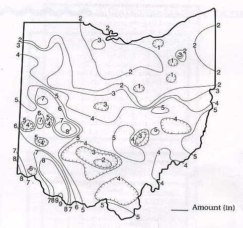
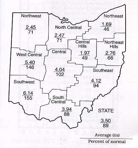
July 2001 Precipitation Maps
Courtesy of the Ohio Department of Natural Resources David H. Cashell Scott Kirk |
|
July 2001 Ohio Weather Data
|
|
Station
|
Max / Min Temperature
|
Mean Temp
|
Precipitation and Max 24 hr precipitation
|
Snowfall and Maximum 24 hr snow
|
High WindGust and Average High Wind Gust
|
High & Low Barometer
|
|
Ada #115
|
-
|
-
|
-
|
-
|
-
|
-
|
|
Akron-Canton NWS
|
93 (24) / 47 (2,6)
|
70.8
|
1.18 / 0.65 (8)
|
0
|
30 (5)
|
30.32 (2) / 29.70 (10)
|
|
Alliance 7S #21
|
91 (24) / 42 (2)
|
71.2
|
2.34 / 1.56 (8)
|
0
|
12 (11) / 10.0
|
x / 29.54 (5)
|
|
Athens 1S
|
-
|
-
|
-
|
-
|
-
|
-
|
|
Aurora 3S #3
|
96 (24) / 40 (2)
|
69.9
|
1.77 / 0.69 (8)
|
0
|
-
|
-
|
|
-
|
-
|
-
|
-
|
-
|
-
|
|
|
95 (31) / 48 (2)
|
74.6
|
3.22 / 0.98 (18)
|
0
|
26 (8) / 14.7
|
30.32 (2) / 29.82 (10)
|
|
|
Chillicothe 3S #40
|
93 (26) / 51 (28,29)
|
72.5
|
1.90 / 0.55 (22)
|
0
|
-
|
-
|
|
Cincinnati 5NW #13
|
91 (23,25) / 52 (6)
|
74.7
|
7.15 / 2.94 (18)
|
0
|
E60 (8) / -
|
-
|
|
Cincinnati NWS
|
91 (31) / 52 (6)
|
74.2
|
8.70 / 3.11 (18)
|
0
|
61 (8) / -
|
30.26 (2) / 29.76 (10)
|
|
Cleveland NWS
|
93 (23,24) / 50 (6)
|
71.9
|
0.68 / 0.47 (25)
|
0
|
32 (10) / -
|
30.34 (2) / 29.70 (10)
|
|
Cleves 2NW
|
95 (23,25) / 51 (6)
|
-
|
-
|
-
|
27 (x) / 11.6
|
30.20 (-) / 29.78 (-)
|
|
Columbus 5NW #9
|
94 (24) / 50 (6)
|
73.6
|
3.81 / 1.74 (25)
|
0
|
26 (25) / -
|
-
|
|
Columbus NWS
|
93 (23) / 53 (6)
|
74.3
|
4.67 / 2.40 (25)
|
0
|
37 (24) / -
|
30.29 (2) / 29.71 (10)
|
|
Dayton NWS
|
90 (24) / 49 (2)
|
73.3
|
5.48 / 1.60 (29)
|
0
|
47 (2) / -
|
30.29 (2) / 29.76 (10)
|
|
Ellet 1NW #118
|
94 (24) / 46 (2)
|
-
|
0.49 / 0.26 (7)
|
0
|
20 (5) / -
|
30.34 (31) / 29.83 (10)
|
|
Holgate 1SE #8
|
-
|
-
|
-
|
-
|
-
|
-
|
|
93 (24) / 42 (2)
|
70.1
|
3.35 / 1.20 (25)
|
0
|
16 (5,23) / 11.0
|
30.27 (2) / 29.68 (10)
|
|
|
Kent 2W #53
|
94 (24) / 43 (2)
|
69.6
|
2.28 / 0.99 (22)
|
0
|
25 (1) / 16.2
|
30.32 (2) / 29.76 (10)
|
|
Kidron 1N #2
|
93 (31) / 45 (2)
|
72.6
|
2.57 / 1.57 (19)
|
0
|
12 (1,5,10) / 6.0
|
30.34 (2) / 29.77 (10)
|
|
Lagrange 2SW #87
|
96 (24) / 48 (6)
|
72.3
|
2.32 / 1.09 (19)
|
0
|
25 (26) / 16.9
|
30.30 (27) / 29.71 (10)
|
|
Lancaster 4N #17
|
93 (x) / 51 (x)
|
-
|
3.39 / 1.02 (x)
|
0
|
23 (5,24) / -
|
-
|
|
Lancaster 1E #30
|
-
|
-
|
-
|
-
|
-
|
-
|
|
Loveland 1N #83
|
-
|
-
|
-
|
-
|
-
|
-
|
|
Mansfield NWS
|
92 (24) / 47 (6)
|
70.9
|
1.05 / 0.56 (1)
|
0
|
39 (9) / -
|
30.31 (2) / 29.73 (10)
|
|
96 (24) / 43 (2)
|
70.6
|
1.66 / 1.31 (26)
|
0
|
27 (5) / 16.3
|
30.28 (27) / 29.75 (10)
|
|
|
Newcomerstown 1S #106
|
93 (23) / 46 (2,6)
|
71.3
|
3.20 / 1.30 (25)
|
0
|
35 (24) / 15.9
|
-
|
|
New Philadelphia 1NW #58
|
89 (23) / 46 (2)
|
74.5
|
3.07 / 1.22 (1)
|
0
|
30 (1) / -
|
30.19 (3) / 29.76 (10)
|
|
North Ridgeville 1N #32
|
98 (23) / 48 (6,27)
|
72.3
|
0.45 / 0.21 (25)
|
0
|
25 (4,26) / 16.7
|
30.28 (2) / 29.65 (10)
|
|
Ottawa 4E #15
|
93 (24) / 43 (2)
|
72.4
|
3.55 / 2.03 (25)
|
0
|
27 (26) / 17.2
|
30.23 (2) / 29.23 (10)
|
|
Oxford #108
|
-
|
-
|
-
|
-
|
-
|
-
|
|
Perry 3SE #38
|
92 (23) / 48 (6)
|
71.3
|
2.15 / 1.64 (15)
|
0
|
-
|
-
|
|
Perrysville 4W #79
|
94 (24) / 47 (3)
|
71.5
|
1.01 / 0.39 (9)
|
0
|
18 (7&25) / 10.1
|
-
|
|
Port Clinton 3W #14
|
94 (23,24) / 53 (6)
|
74.1
|
2.00 / 1.10 (26)
|
0
|
39 (29) / 19.2
|
30.32 (2) / 29.71 (10)
|
|
-
|
-
|
-
|
-
|
-
|
-
|
|
|
Rockbridge 4W #33
|
92 (23,24) / 50 (2)
|
72.2
|
5.57 / 2.24 (29)
|
0
|
-
|
-
|
|
Rocky River 1W #51
|
-
|
-
|
1.69 / 0.76 (7)
|
-
|
-
|
-
|
|
Sabina #113
|
-
|
-
|
2.26 / 0.76 (25)
|
-
|
-
|
-
|
|
Sandusky 1N #4
|
93 (23) / 56 (3)
|
73.5
|
1.90 / 1.55 (25)
|
0
|
28 (10) / 18.2
|
30.33 (2) / 29.73 (10)
|
|
Sharonville 2NE #43
|
-
|
-
|
-
|
-
|
-
|
-
|
|
Springfield 2N #1
|
93 (10,23) / 50 (2)
|
74.4
|
8.02 / 3.39 (29)
|
0
|
29 (1) / -
|
30.28 (2) / 29.82 (10)
|
|
Spring Valley 2E #62
|
-
|
-
|
-
|
-
|
-
|
-
|
|
Stow 1SE #105
|
98 (23) / 52 (3)
|
64.9
|
1.61 / 1.28 (25)
|
0
|
-
|
30.39 (27) / 29.83 (10)
|
|
-
|
-
|
-
|
-
|
-
|
-
|
|
|
Sugarcreek 2SW #112
|
91 (23) / 45 (6)
|
70.4
|
2.17 / 1.14 (25)
|
0
|
31 (1) / 14.5
|
30.29 (2,31)/29.82 (10)
|
|
Tiltonsville #117
|
91 (24) / 49 (2)
|
72.6
|
3.86 / 1.55 (25)
|
0
|
31 (25) / -
|
30.34 (2) / 29.73 (11)
|
|
Toledo 5NE #66
|
93 (24) / 46 (6)
|
72.3
|
1.78 / 0.85 (29)
|
0
|
40 (29) / -
|
30.33 (2) / 29.70 (10)
|
|
Toledo NWS
|
94 (23) / 46 (2)
|
72.7
|
2.01 / 0.96 (25)
|
0
|
44 (29) / -
|
30.32 (2) / -
|
|
Van Wert #86
|
95 (20,23,24) / 48 (2)
|
75.8
|
3.18 / 1.72 (21)
|
0
|
65 (21) / 18.0
|
30.26 (2) / 29.73 (10)
|
|
93 (24) / 44 (2)
|
71.2
|
1.15 / 0.27 (1)
|
0
|
37 (10) / 16.6
|
30.27 (2) / 29.72 (11)
|
|
|
Youngstown NWS
|
94 (24) / 40 (2)
|
69.6
|
2.02 / 0.92 (25)
|
0
|
44 (1) / -
|
30.33 (27) / 29.69 (11)
|
|
Zanesville 6N #48
|
89 (10) / 50 (3)
|
70.8
|
3.96 / 0.83 (1)
|
0
|
18 (1) / -
|
30.32 (2) / 29.75 (10)
|
|