|
August 2001 Ohio Weather Observer Network Weather summaries, Station Data and Network News E-Mail: lrhuff@megsinet.net www.ohioweather.net |
|
OWON transfer on schedule
The transfer of the Ohio Weather Observer Network to Kent State University is on schedule. Beginning October 1st , all OWON weather data will be submitted to Dr. Scott Sheridan, Assistant Professor Climatology, Department of Geography at KSU. Scott will handle the day-to-day administration of the network while overseen by Dr. Tom Schmidlin. Beginning October 1st., OWON observers will have three options in submitting data. The main option is through Scott's web site that is still under developement at: http://sheridan.geog.kent.edu/owon/. Other options are: fax (330-672-4304) and mail (Dr. Scott Sheridan, Kent State University, P.O. Box 5190, Kent, OH 44242-0001). Transfer has already been made regarding the OhioWx e-Group. That is now moderated by Matt Higgins, longtime OWON observer, now located near Lodi, Ohio. Matt will also moderate this season's OhioSnowReport. To contact Matt to be on this list, e-mail him at: weatherman71@hotmail.com |


|
Matt Higgins OhioWx e-Group and OhioSnowReport
|
|
Dr. Scott Sheridan & Dr. Tom Schmidlin Ohio Weather Observer Network
|
|
Weather Station Summaries
|
| Springfield 2N #1 (Clark County) Dick Groeber - The temperatures began warm and gradually cooled. The first week saw the heat wave of July 2001 holding on with daily highs in the 90s through the 10th. This kept the overall readings above normal. The big story was the rainfall. It was sporadic, averaging around normal until a storm siege at the end of the month on the 30th and 31st. Warm and humid air between warm and cold fronts gave a two and one half hour strong thunderstorm on the 30th. Rainfall was 3.20 inches along with intense lightning causing sporadic power outages and small hail. This caused street and parking lot flooding. A second storm followed, producing an additional 0.48 inch. The total for the day was 3.68 inches. On the 31st, three additional storms hit producing a total of 0.89 inch. The two-day total was 4.57 inches. The total on the 30th was the 5th heaviest one-day total on record for this station. This brought the month total to 7.97 inches which was the 2nd greatest for an August here since 1968. The greatest month total was 9.65 inches in 1978.
Kent 2W #53 (Portage County) Eric Wertz - August 2001 began with well above normal temperatures from the 1st through the 10th with temperatures falling a little below normal after the second week of the month to leave a mean temperature that was normal for August. Heat wave conditions persisted from the 6th through the 9th with temperatures of at least 90 degrees each afternoon and heat indexes as high as 100 degrees. Measurable precipitation occurred on 12 days with a monthly total of 3.77 inches being normal. This helped somewhat with the extremely dry conditions that persisted the previous month. There were 5 thunderstorm days and 6 fog days noted with one warning and one advisory issued. Heaviest rains were 0.99 on the 3rd. Stormy weather occurred on the 9th and 31st. Perrysville 4W #79 (Richland County) Katie Gerwig - The month of August was warmer than normal with 6 days over 90 degrees. Rainfall was normal. There were 7 thunderstorm days. No storms were especially severe. Ravenna 1E #101 (Portage County) Rich Rabatin - There were two exceptional weather events here in Ravenna. The first was on the afternoon of August 9th as a line of severe weather pushed through the area. A severe thunderstorm warning was issued shortly after 5:00 pm for Portage County. The storm hit Ravenna around 5:15 pm with high winds, blinding rain, and vivid cloud to cloud/cloud to ground lightning. The highest wind gust came at 5:23 pm measured at 45mph. About a minute later, lightning struck a power pole close by knocking out power to the area for about an hour. The winds also brought down several large limbs and some trees. The storm lasted almost 45 minutes, and during that time, I measured 1.03" of rain. The second event came on the 31st of August as heavy rains and thunderstorms hit Portage County. Although the storms were not severe, Ravenna received 1.46" of rain. There was some street flooding and flooded basements in the area (not mine thank God) but nothing major. The rains in August greened up the dried out lawns in the area, meaning more grass cutting time. Cincinnati 5NW #13 (Hamilton County) Ronald E. Rothhaas Jr. - August was warm, 2.1 degrees above normal, and slightly wetter than normal (+0.36 inch). It continued the July trend of high humidity with dew points of 70 or above on an oppresive19 days! Truly the dog days. With all that moisture there was fog on 13 days and thunder on 13 days. Plant and lawn funguses are thrilled. Wooster 7N #16 (Wayne County) Jack Sisler - Mean temperatures were almost three degrees above normal with six 90 degree days all within the first ten days of the month. Precipitation was almost three-fourths below normal bringing the yearly deficit to almost 7.50 inches. No severe weather occured. Kidron 1N #2 (Wayne County) Ronald A. Hahn - Thanks to the very warm first part of the month, August temperatures averaged more than two degrees above normal. Rainfall was much above normal with the 6.05 inches making this the 4th wettest August of record here.
|
|
August 2001 weather extremes from all available weather stations including the OWON
|
|
-
|
READING
|
DATE
|
STATION (s)
|
|
Highest Temperature
|
99
|
8th
|
Kidron 1N (Wayne County)
|
|
Lowest Temperature
|
44
|
15th
|
Aurora 3S (Portage County)
|
|
Highest Precipitation
|
9.36
|
-
|
Rocky River 1W (Cuyahoga County)
|
|
Lowest Precipitation
|
1.98
|
-
|
Brunswick (Medina County)
|
|
Highest Snowfall
|
0
|
-
|
-
|
|
Highest Wind Gust
|
45
|
-
|
Ravenna 1E (Portage County)
|
|
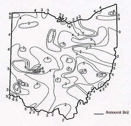
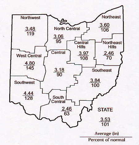
August 2001 Precipitation Maps
Courtesy of the Ohio Department of Natural Resources David H. Cashell Scott Kirk |
|
August 2001 Ohio Weather Data
|
|
Station
|
Max / Min Temperature
|
Mean Temp
|
Precipitation and Max 24 hr precipitation
|
Snowfall and Maximum 24 hr snow
|
High WindGust and Average High Wind Gust
|
High & Low Barometer
|
|
Akron-Canton NWS
|
95 (9) / 54 (29)
|
72.4
|
4.01 / 1.02 (10)
|
0
|
38 (9) / -
|
30.29 (1) / 29.78 (19)
|
|
Alliance 7S #21
|
98 (8) / 51 (24)
|
72.8
|
5.86 / 2.07 (31)
|
0
|
11 (7) / 8.0
|
-
|
|
Aurora 3S #3
|
97 (8) / 44 (15)
|
71.0
|
3.89 / 1.02 (3)
|
0
|
-
|
-
|
|
Brunswick 2NE #116
|
-
|
-
|
1.98 / 0.60 (27)
|
-
|
-
|
-
|
|
94 (1) / 52 (21)
|
75.1
|
6.52 / 1.35 (26)
|
0
|
-
|
30.35 (1) / 29.81 (19)
|
|
|
Chillicothe 3S #40
|
94 (8,10) / 36 (20)
|
73.4
|
2.06 / 0.91 (19)
|
0
|
-
|
-
|
|
Cincinnati 5NW #13
|
92 (8) / 57 (21)
|
75.6
|
3.71 / 1.12 (18)
|
0
|
-
|
-
|
|
Cincinnati NWS
|
91 (8) / 55 (21)
|
74.9
|
5.00 / 1.36 (19)
|
0
|
38 (25) / -
|
30.27 (1) / 29.77 (19)
|
|
Cleveland NWS
|
94 (8) / 51 (15)
|
72.6
|
3.31 / 1.63 (3)
|
0
|
43 (9) / -
|
30.31 (1) / 29.76 (19)
|
|
Cleves 2NW
|
96 (8) / 57 (15)
|
-
|
6.65 / x
|
-
|
22 (x) / 11.9
|
30.28 (1) / 29.79 (19)
|
|
Columbus 5NW #9
|
92 (8-9) / 52 (15)
|
74.8
|
5.44 / 3.22 (31)
|
0
|
27 (16)
|
-
|
|
Columbus NWS
|
93 (9) / 55 (15)
|
75.2
|
4.15 / 2.35 (31)
|
0
|
38 (16) / -
|
30.28 (1) / 29.75 (9)
|
|
Dayton NWS
|
91 (8) / 56 (15)
|
73.5
|
6.40 / 1.43 (31)
|
0
|
40 (9) / -
|
30.30 (1) / 29.78 (19)
|
|
Ellet 1NW #118
|
95 (8) / 52 (15)
|
-
|
3.42 / 1.42 (9)
|
0
|
18 (26) / -
|
-
|
|
Holgate 1SE #8
|
-
|
-
|
-
|
-
|
-
|
-
|
|
95 (8) / 47 (15)
|
71.2
|
5.88 / 1.53 (9)
|
0
|
16 (9) / 9.0
|
30.25 (1) / 29.74 (19,31)
|
|
|
Kent 2W #53
|
95 (8) / 47 (15)
|
71.1
|
3.77 / 0.99 (3)
|
0
|
27 (26) / 14.5
|
30.33 (1) / 29.80 (31)
|
|
Kidron 1N #2
|
99 (8) / 50 (15)
|
73.8
|
6.05 / 2.23 (9)
|
0
|
10 (9,16,17,18) /6.0
|
30.34 (1) / 29.83 (19)
|
|
Lagrange 2SW #87
|
96 (8) / 51 (15)
|
73.4
|
2.61 / 0.79 (9)
|
0
|
28 (9) / 16.2
|
30.31 (1) / 29.77 (18)
|
|
Lancaster 4N #17
|
93 (x) / 52 (x)
|
-
|
5.96 / 1.41 (x)
|
0
|
22 (18) / -
|
-
|
|
Lancaster 1E #30
|
-
|
-
|
-
|
-
|
-
|
-
|
|
Lodi 2S #23
|
96 (8) / 48 (15)
|
73.3
|
2.94 / 0.70 (3)
|
0
|
-
|
30.27 (1,2) / 29.84 (19,31)
|
|
Loveland 1N #83
|
-
|
-
|
-
|
-
|
-
|
-
|
|
Mansfield NWS
|
91 (8) / 47 (15)
|
71.1
|
4.30 / 1.39 (3)
|
0
|
30 (16) / -
|
30.30 (1) / 29.76 (19)
|
|
95 (8) / 49 (15)
|
71.9
|
3.10 / 0.68 (4)
|
0
|
27 (26) / 15.3
|
30.26 (1) / 29.81 (19)
|
|
|
Newcomerstown 1S #106
|
95 (8) / 50 (15)
|
72.4
|
9.03 / 4.37 (12)
|
0
|
28 (9) / 14.5
|
-
|
|
New Philadelphia 1NW #58
|
95 (8) / 50 (15)
|
70.5
|
2.25 / 1.16 (31)
|
0
|
20 (26) / -
|
30.20 (1) / 29.80 (19)
|
|
North Ridgeville 1N #32
|
-
|
-
|
-
|
-
|
-
|
-
|
|
Ottawa 4E #15
|
93 (8) / 50 (15)
|
72.7
|
3.17 / 0.87 (21)
|
0
|
29 (30) / 17.7
|
30.19 (1) / 29.52 (19,20)
|
|
Perry 3SE #38
|
93 (2) / 52 (15)
|
72.0
|
4.88 / 2.28 (7)
|
0
|
-
|
-
|
|
Perrysville 4W #79
|
95 (8) / 47 (15)
|
71.8
|
3.65 / 1.13 (31)
|
0
|
21 (17) / 10.6
|
-
|
|
Port Clinton 3W #14
|
97 (8) / 57 (15)
|
71.9
|
3.40 / 1.23 (3)
|
0
|
37 (16) / 20.3
|
30.30 (1) / 29.75 (19)
|
|
98 (8) / 55 (15)
|
71.9
|
6.96 / 1.46 (31)
|
0
|
45 (9) / 13.7
|
30.14 (1) / 29.66 (31)
|
|
|
Rockbridge 4W #33
|
91 (7,8) / 55 (15)
|
73.6
|
2.41 / 0.53 (19)
|
0
|
-
|
-
|
|
Rocky River 1W #51
|
-
|
-
|
9.36 / -
|
-
|
-
|
-
|
|
Sabina #113
|
-
|
-
|
3.56 / 0.81 (31)
|
0
|
-
|
-
|
|
Sandusky 1N #4
|
95 (8) / 54 (15)
|
73.8
|
2.89 / 1.28 (3)
|
0
|
28 (16) / 17.0
|
30.32 (1) / 29.76 (19)
|
|
Sharonville 2NE #43
|
-
|
-
|
-
|
-
|
-
|
-
|
|
Springfield 2N #1
|
96 (7) / 54 (15)
|
75.9
|
7.97 / 3.68 (30)
|
0
|
29 (16) / 17.0
|
30.32 (9) / 29.81 (19)
|
|
Spring Valley 2E #62
|
-
|
-
|
-
|
-
|
-
|
-
|
|
Stow 1SE #105
|
96 (8) / 53 (15)
|
68.3
|
3.55 / 0.97 (3)
|
0
|
-
|
30.39 (1) / 29.91 (20)
|
|
-
|
-
|
-
|
-
|
-
|
-
|
|
|
Sugarcreek 2SW #112
|
96 (8) / 48 (15)
|
72.5
|
2.55 / 1.05 (31)
|
0
|
26 (9) / 14.5
|
30.33 (1) / 29.88 (31)
|
|
Tiltonsville #117
|
94 (8) / 54 (15)
|
74.7
|
2.37 / 1.07 (31)
|
0
|
24 (16) / -
|
30.34 (1) / 29.81 (19)
|
|
Toledo 5NE #66
|
-
|
-
|
-
|
-
|
-
|
-
|
|
Toledo NWS
|
97 (8) / 50 (15)
|
73.4
|
2.48 / 1.47 (23)
|
0
|
33 (16) / -
|
30.28 (1) / 29.73 (19)
|
|
Van Wert #86
|
-
|
-
|
-
|
-
|
-
|
-
|
|
95 (1) / 46 (15)
|
71.9
|
2.96 / 0.84 (31)
|
0
|
26 (26) / 14.6
|
30.27 (6) / 29.85 (31)
|
|
|
Youngstown NWS
|
95 (8) / 48 (15)
|
71.6
|
3.87 / 1.37 (31)
|
0
|
33 (26) / -
|
30.32 (1) / 29.78 (19)
|
|
Zanesville 6N #48
|
92 (8) / 54 (15)
|
72.1
|
3.13 / 1.27 (12)
|
0
|
17 (16) / -
|
30.32 (1) / 29. 83 (19)
|
|