|
April 2001 Ohio Weather Observer Network Weather summaries, Station Data and Network News E-Mail: lrhuff@megsinet.net www.ohioweather.net |
|
Weather Station Summaries
Some mild drought in southwest Ohio areas |
| Toledo 5NE #66 (Lucas County) Mike Bielski - Sleet was recorded along with a trace of snowfall on April 1st. There were 13 precipitation days and 6 days with thunder and 4 actual thunderstorms at my location. There was a severe thunderstorm warning for southern and eastern Lucas County on April 7th. At 3:30 pm on the 7th, the temperature at my location was 58 degrees with an east wind of 5 mph. The warm front passed and at 4:28 pm the temperature was 76 degrees with a south wind of 10 mph, a rise of 18 degrees in one hour. On April 22, a stationary front slipped just to my south at 7:30 pm and dense fog moved in with a visibility of 1/4 to 1/2 mile. At 8:00 pm, I had 55 degrees with dense fog while the airport was 70 degrees. By 10:00 pm, the fog lifted and the sky was clear and 57 degrees. There was a severe thunderstorm watch issued on April 23 from 4:30 pm to 10:00 pm.
Cincinnati 5NW #13 (Hamilton County) Ronald E. Rothhaas Jr. - The La Nina induced storm and dry pattern kicked into high gear in April with summer-like heat interrupted briefly by snow and cold. Temperatures soared to 86 degrees on the 7th with 80 degrees achieved or topped on six other days. A cold shot dropped temperatures to 29 degrees on the 17th and 18th with 0.5 inch snow early on the 17th, a daily record! After all the warm weather, many trees were out and have shown minor long-term bud kill. The big news is drought. Rainfall deficits have now topped 7 inches here of a normal annual 40 inches. Lawns are already turning brown and we are off to a worse start than in the La Nina induced drought of 1999. The last time we had 1 inch or more of rain in 24 hours was in December. Kent 2W #53 (Portage County) Eric Wertz - April 2001 was warmer than normal with above average high wind gusts. Winds gusted above 20 mph on 14 days; above 30 mph on 3 days and even reached 50 mph on the 12th. The high wind gust of 50 mph at 1:34 pm on the 12th, in association with a powerful low pressure system tracking through the Great Lakes, was only the fourth time that winds were recorded at 50 mph or higher at Kent 2W since records began on June 1, 1979. Total monthly precipitation of 3.50 inches was normal. There were 15 days where measurable liquid equivalent precipitation was observed. Measurable snowfall only occurred on the 17th and was 0.2 inch for the day and month. One severe thunderstorm watch and one wind advisory were issued during the month. Heavy rains of 1.12 inches fell on the 6th. There were two thunderstorm and one fog days. Spring Valley 2E #62 (Greene County) Ed Kramer - Dry conditions and above normal temperatures persisted through the month. Palmer Drought Index listed our area as mild drought by the end of the month. Field work continues ahead of schedule, but a cold outbreak starting on the 16th caused damaging frost and a halt to planting as soil temperatures dropped back into the 40s after a high of 57 degrees on the 12th. A low of 45 degrees at the six inch level was recorded on the 19th. |
|
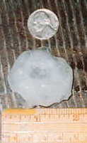
Kidron 1N #2 (Wayne County) Ronald A. Hahn - Rainfall was 1.12 inches above normal for the month of April but the big news ( besides the 2 inch hail on the 9th - photo to the right ) was the temperature. The month's average temperature of 54.2 degrees was more than 5 degrees above normal. The 83 degree temperature on the 7th was the hottest ever so early in the season. We hit 80 degrees or more 5 times in April.
Perrysville 4W #79 (Richland County) Katie Gerwig - Warmer than normal temperatures, especially daytime temperatures, throughout the month. Rainfall was normal to slightly above. Very windy on the 12th with a high wind gust of 50 mph. Trees were downed throughout the area. Rain fell on 13 days but the last 6 days of the month were almost completely clear. |
|
Springfield 2N #1 (Clark County) Dick Groeber - Locally for the month, both temperature and precipitation were above normal. However, precipitation for the year was below normal. The temperatures averaged the warmest levels for the past 33 years of record for this station. The average of nearly 58 degrees was the warmest beating 55 degrees in 1970, 1977, 1981, 1985 and 1991. High temperatures in the 70s and 80s were not uncommon. The high of 88 degrees recorded on the 30th was a degree shy of the record for the month set on April 26, 1986. Chilly morning temperatures in the 30s and 40s were also common. Precipitation was centered around the middle of the month with the bulk of the total occurring during the period of the 9th through the 11th with 3.19 inches of the total 4.73 inches. This occurred from a series of thunderstorms hat helped relieve the dryness of the previous three months. Another series of showers ended with the only snowfall of the month. This tied the date for lateness of snowfall at this station for the past 33 years. The month ended with a week long dry period. Because the previous three months were so dry, the overall year total remained below normal.
Wooster 7N #16 (Wayne County) Jack Sisler - Biggest feature of the month was the great quantity of precipitation. I had 4.18 inches for the month which was almost one inch above normal and the greatest monthly total since May of 2000. Fourteen out of the thirty days had measurable precipitation with only a tenth of an inch of snowfall. Even with a few record breaking low temperatures, mean temperatures for the month were almost five degrees above normal. |
|
Sandusky 1N #4 (Erie County) James Goelz - April 2001 was a rather uneventful month locally except for the high winds from a low pressure system on the 12th. There were 9 days in which wind gusts reached 30 mph or more. Winds gusted to 54 mph on the 12th at 3:56 pm. This was the highest recorded here since December 11, 2000 when winds gusted to 55 mph. High barometric pressure dominated the last half of April from the 17th through the 30th with the highest pressure at 30.56 inches (sea level) on the 29th. There was only a trace of snow the entire month which occurred on the 17th.
Be sure to read last page of this month's report. There you will find the April listing of daily significant weather events reported by observers of the Ohio Weather Observer Network. |
|
April 2001 Weather Extremes
|
|
-
|
READING
|
DATE
|
STATION (s)
|
|
Highest Temperature
|
88
|
30th
|
Lancaster 4N (Fairfield Co.) & Springfield 2N (Clark Co.)
|
|
Lowest Temperature
|
22
|
4th
|
Aurora 3S (Portage Co.) & Lagrange 2SW (Lorain Co.)
|
|
Highest Precipitation
|
7.29
|
-
|
Hannibal Lock & Dam (Monroe County)
|
|
Lowest Precipitation
|
1.07
|
-
|
Salem Center (Meigs County)
|
|
Highest Snowfall
|
1.6
|
-
|
Rockbridge 4W (Hocking Co.)
|
|
Highest Wind Gust
|
59
|
12th
|
Oxford (Butler Co.)
|
|
Around The Network by Larry Huff
|

|
It is with great sadness that we report the death of one of our OWON observers, Don Diller. He began reporting Coldwater, Ohio weather on December 9, 1998. This came after his son-in-law and daughter had given him a Davis Weather Wizard II as a Christmas present. Don suffered a stroke on April 5th and passed away on May 1, 2001. His wife, Rita, wrote to say that "he sure enjoyed doing this (weather observing) while he was able". We will certainly miss Don and his faithfullness in submitting weather data to this network. |
|
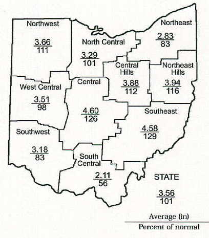
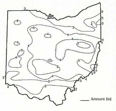
April 2001 Precipitation Maps
Courtesy of the Ohio Department of Natural Resources David H. Cashell Scott Kirk |
|
April 2001 Ohio Weather Data
|
|
Station
|
Max / Min Temperature
|
Mean Temp
|
Precipitation and Max 24 hr precipitation
|
Snowfall and Maximum 24 hr snow
|
High WindGust and Average High Wind Gust
|
High & Low Barometer
|
|
Ada #115
|
81 (7) / 27 (17)
|
54.6
|
3.63 / -
|
-
|
-
|
-
|
|
Akron-Canton NWS
|
81 (7) / 26 (17)
|
52.5
|
3.53 / 1.43 (6)
|
1.1 / 1.1 (17)
|
51 (12) / -
|
30.57 (29) / 29.62 (15)
|
|
Alliance 7S #21
|
-
|
-
|
-
|
-
|
-
|
-
|
|
Athens 1S
|
-
|
-
|
-
|
-
|
-
|
-
|
|
Aurora 3S #3
|
80 (12,13) / 22 (4)
|
51.2
|
4.00 / 1.36 (7)
|
0.6 / 0.3 (1,17)
|
-
|
-
|
|
82 (7) / 27 (19)
|
52.9
|
3.35 / 1.38 (6)
|
-
|
42 (12) / 20.3
|
30.56 (29) / 29.64 (15)
|
|
|
86 (7) / 27 (18)
|
57.7
|
3.14 / 0.78 (11)
|
0
|
46 (12) / 22.5
|
30.53 (29) / 29.64 (15)
|
|
|
Chillicothe 3S #40
|
86 (10) / 28 (2)
|
56.3
|
3.22 / 1.36 (10)
|
0
|
-
|
-
|
|
Cincinnati 5NW #13
|
86 (7) / 29 (2,17,18)
|
58.7
|
2.60 / 0.66 (11)
|
0.5 / 0.5 (17)
|
-
|
-
|
|
Cincinnati NWS
|
85 (9) / 26 (18)
|
57.8
|
1.46 / 0.42 (1)
|
0.7 / 0.5 (17)
|
43 (12) / -
|
30.47 (29) / 29.62 (15)
|
|
Cleveland NWS
|
82 (12) / 25 (4)
|
51.4
|
2.33 / 0.78 (6)
|
0.3 / 0.3 (17)
|
52 (12) / -
|
30.60 (29) / 29.61 (12)
|
|
Columbus 5NW #9
|
83 (7,9) / 27 (2)
|
56.1
|
4.14 / 1.23 (11)
|
0.4 / -
|
37 (12) / -
|
-
|
|
Columbus NWS
|
83 (12) / 28 (2)
|
56.8
|
3.39 / 1.02 (11)
|
0.8 / 0.6 (17)
|
51 (12) / -
|
30.52 (29) / 29.59 (15)
|
|
Dayton NWS
|
85 (7) / 29 (18)
|
55.9
|
3.60 / 2.01 (11)
|
0.2 / 0.1 (17)
|
52 (23) / -
|
30.54 (29) / 29.64 (15)
|
|
Holgate 1SE #8
|
82 (30) / 27 (2)
|
53.0
|
5.91 / 3.63 (6)
|
0
|
45 (12) / -
|
30.63 (29) / 29.73 (12)
|
|
82 (7) / 24 (4)
|
52.4
|
3.65 / 0.98 (6)
|
0.8 / 0.5 (17)
|
34 (12) / 14.7
|
30.54 (29) / 29.65 (12)
|
|
|
Kent 2W #53
|
81 (12) / 23 (4)
|
50.9
|
3.50 / 1.12 (6)
|
0.2 / 0.2 (17)
|
50 (12) / 21.5
|
30.56(29) /29.68 (1,15)
|
|
Kidron 1N #2
|
83 (7) / 25 (2,4)
|
54.2
|
4.61 / 1.08 (9)
|
T / T (9, 16, 17,18)
|
28 (12) / 15.0
|
30.55 (29) / 29.63 (15)
|
|
Lagrange 2SW #87
|
83 (30) / 22 (4)
|
51.6
|
3.41 / 1.80 (6)
|
0.3 / 0.3 (17)
|
49 (12) / 24.2
|
30.55 (27,28) /29.64 (12)
|
|
Lancaster 4N #17
|
88 (x) / 32 (x)
|
-
|
4.76 / 1.19 (x)
|
-
|
-
|
-
|
|
Lancaster 1E #30
|
-
|
-
|
-
|
-
|
-
|
-
|
|
Loveland 1N #83
|
-
|
-
|
-
|
-
|
-
|
-
|
|
Mansfield NWS
|
80 (9) / 25 (2)
|
52.3
|
4.21 / 1.23 (6)
|
0.5 / 0.3 (17)
|
51 (12) / -
|
30.57 (29) / 29.63 (15)
|
|
84 (7) / 25 (4)
|
51.3
|
3.30 / 0.87 (6)
|
0.1 / 0.1 (17)
|
42 (12) / 22.8
|
30.51 (29) / 29.68 (15)
|
|
|
Newcomerstown 2W #99
|
-
|
-
|
-
|
-
|
-
|
-
|
|
Newcomerstown 1S #106
|
84 (7) / 24 (2)
|
54.7
|
3.31 / 0.95 (20)
|
0.7 / 0.6 (17)
|
41 (12) / 22.5
|
-
|
|
New Philadelphia 1NW #58
|
83 (7) / 24 (2)
|
50.1
|
3.87 / 0.87 (6)
|
T / T (17)
|
40 (12) / -
|
30.37 (19) / 29.62 (15)
|
|
North Ridgeville 1N #32
|
84 (8) / 23 (4)
|
51.8
|
2.33 / 0.87 (6)
|
T / T (x)
|
49 (12) / 21.4
|
30.55 (29) / 29.56 (12)
|
|
Ottawa 4E #15
|
81 (7) / 24 (2)
|
53.5
|
4.56 / 1.46 (6)
|
T / T (16,17)
|
49 (12) / 28.3
|
30.50 (29) / 29.41 (12)
|
|
Oxford #108
|
84 (7) / 29 (17)
|
58.8
|
2.04 / 0.64 (11)
|
-
|
59 (12) / -
|
-
|
|
Perry 3SE #38
|
82 (23) / 26 (4,19)
|
49.6
|
2.77 / 0.74 (6)
|
0.1 / 0.1 (x)
|
-
|
-
|
|
Perrysville 4W #79
|
81 (8) / 23 (2)
|
53.5
|
3.62 / 0.82 (20)
|
T / T (17)
|
50 (12) / 22.6
|
-
|
|
Port Clinton 3W #14
|
80 (7,23) / 30 (2)
|
51.9
|
2.77 / 0.67 (6)
|
T / T (18)
|
57 (12) / 27.6
|
30.55 (29) / 29.58 (12)
|
|
-
|
-
|
-
|
-
|
-
|
-
|
|
|
Rockbridge 4W #33
|
85 (9) / 27 (18)
|
57.1
|
5.25 / 1.78 (11)
|
1.6 / 1.6 (17)
|
-
|
-
|
|
Rocky River 1W #51
|
-
|
-
|
2.64 / 0.86 (6)
|
T / T (17)
|
-
|
-
|
|
Sabina #113
|
-
|
-
|
5.27 / 2.10 (9)
|
-
|
-
|
-
|
|
Sandusky 1N #4
|
81 (7) / 30 (2)
|
51.9
|
2.72 / 0.94 (6)
|
T / T (17)
|
54 (12) / 24.6
|
30.56 (29) / 29.62 (12)
|
|
Sharonville 2NE #43
|
85 (x) / 29 (x)
|
59.4
|
2.89 / 0.96 (x)
|
0.5 / 0.5 (x)
|
36 (12,16) / -
|
30.52 (29) / 29.68 (15)
|
|
Springfield 2N #1
|
88 (30) / 27 (2)
|
57.9
|
4.73 / 1.35 (9)
|
1.5 / 1.5 (7)
|
44 (12) / 23.0
|
30.50 (29) / 29.61 (15)
|
|
Spring Valley 2E #62
|
85 (7) / 30 (17)
|
57.8
|
1.89 / 0.56 (11)
|
0
|
20 (21) / 13.9
|
30.55 (29 / 29.65 (15)
|
|
Stow 1SE #105
|
84 (23) / 29 (4,17,19)
|
56.0
|
3.04 / 0.79 (6)
|
T / T (1,17)
|
-
|
30.39(29) / 29.53 (1,15,16)
|
|
84 (12) / 24 (4)
|
57.9
|
3.44 / 1.16 (6)
|
1.4 / 0.8 (16,17)
|
44 (25) / 19.8
|
-
|
|
|
Sugarcreek 2SW #112
|
82 (7) / 25 (2)
|
53.8
|
2.39 / 0.61 (20)
|
T / T (17)
|
43 (12) / 20.7
|
30.48 (28) / 29.82 (15)
|
|
Toledo 5NE #66
|
81 (23) / 28 (17)
|
50.6
|
2.35 / 0.53 (6)
|
T / T (1)
|
58 (12) / -
|
30.56 (29) / 29.55 (12)
|
|
Toledo NWS
|
81 (30) / 26 (2)
|
51.5
|
2.47 / 0.72 (6)
|
T / T (17)
|
58 (12) / -
|
30.55 (29) / 29.55 (12)
|
|
79 (30) / 24 (17)
|
53.2
|
4.18 / 1.16 (6)
|
0.1 / 0.1 (17)
|
51 (12) / 23.8
|
30.54 (29) / 29.65 (1)
|
|
|
Youngstown NWS
|
83 (12) / 24 (19)
|
51.2
|
2.71 / 0.77 (7)
|
0.9 / 0.6 (17)
|
54 (12) / -
|
30.58 (29) / 29.64 (15)
|
|
Zanesville 6N #48
|
83 (7,20,23) / 30 (17,18)
|
56.4
|
4.26 / 1.03 (6)
|
0
|
34 (12) / -
|
30.53 (29) / 29.60 (15)
|
|